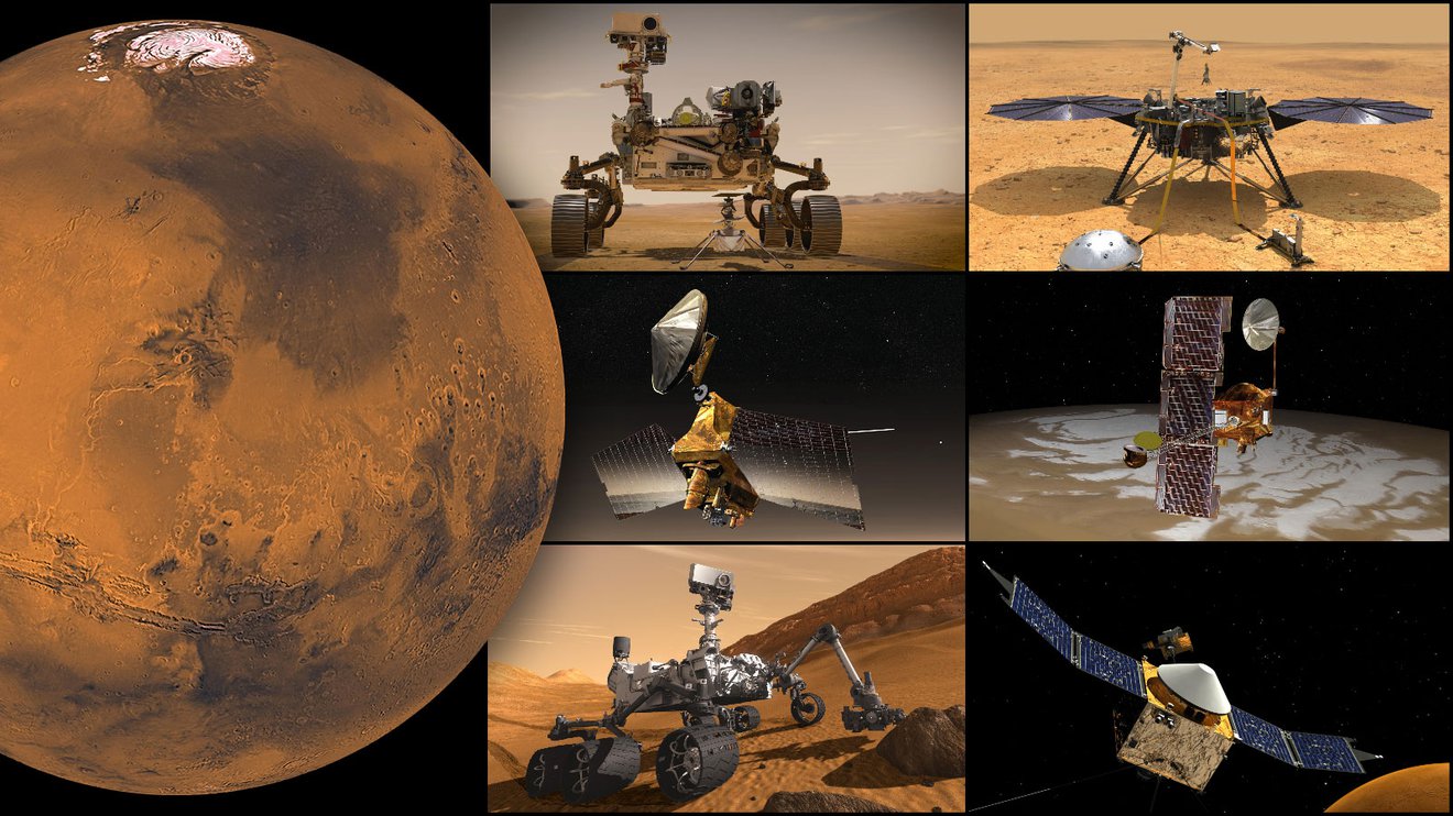
NASA: Jet Propulsion Laboratory News – Month in Review – October 2021
JPL News – Month in Review
Friday, October 1, 2021 |
|||||||||||||||||||||||||||||||||||||||||||||||||
|
|
|||||||||||||||||||||||||||||||||||||||||||||||||
|
|||||||||||||||||||||||||||||||||||||||||||||||||


This message was sent to ingpeaceproject@gmail.com from jplnewsroom@jpl.nasa.gov
NASA’s Jet Propulsion Laboratory
NASAJPL
4800 Oak Grove Dr
Pasadena, CA 91109
NASA’s Perseverance Rover Cameras Capture Mars Like Never Before
Sep 23, 2021
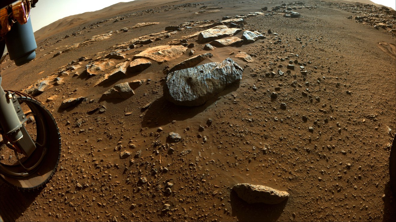
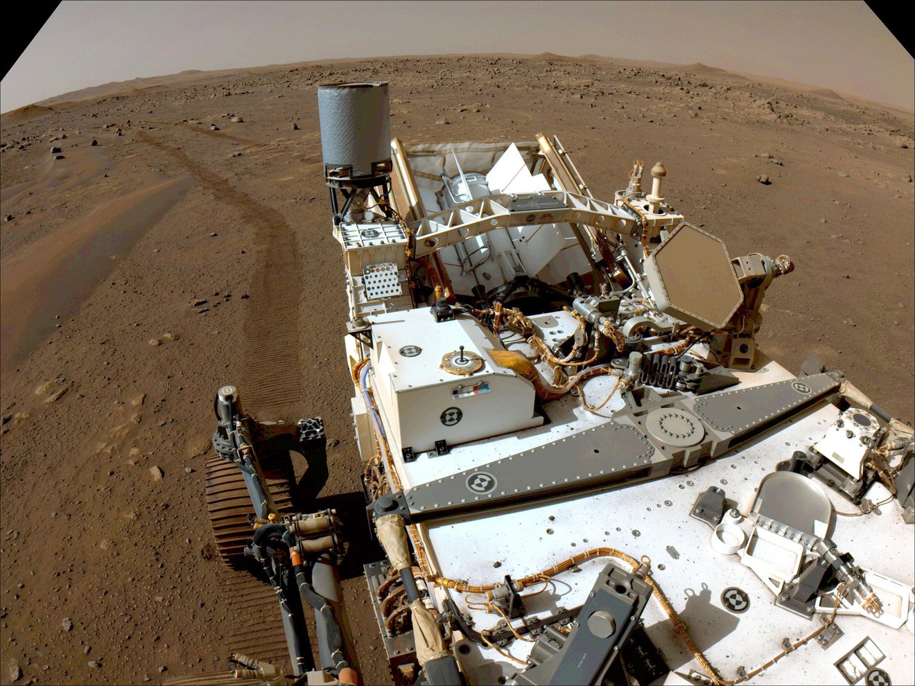
 Using its WATSON camera, NASA’s Perseverance Mars rover took this selfie over a rock nicknamed “Rochette,” on Sept.10, 2021, the 198th Martian day, or sol, of the mission. Two holes can be seen where the rover used its robotic arm to drill rock core samples.
Credit: NASA/JPL-Caltech/MSSS
Scientists tap into an array of imagers aboard the six-wheeled explorer to get a big picture of the Red Planet.
NASA’s Perseverance rover has been exploring Jezero Crater for more than 217 Earth days (211 Martian days, or sols), and the dusty rocks there are beginning to tell their story – about a volatile young Mars flowing with lava and water.
That story, stretching billions of years into the past, is unfolding thanks in large part to the seven powerful science cameras aboard Perseverance. Able to home in on small features from great distances, take in vast sweeps of Martian landscape, and magnify tiny rock granules, these specialized cameras also help the rover team determine which rock samples offer the best chance to learn whether microscopic life ever existed on the Red Planet.
Altogether, some 800 scientists and engineers around the world make up the larger Perseverance team. That includes smaller teams, from a few dozen to as many as 100, for each of the rover’s cameras and instruments. And the teams behind the cameras must coordinate each decision about what to image.
“The imaging cameras are a huge piece of everything,” said Vivian Sun, the co-lead for Perseverance’s first science campaign at NASA’s Jet Propulsion Laboratory in Southern California. “We use a lot of them every single day for science. They’re absolutely mission-critical.”
Mars Report: Update on NASA’s Perseverance Rover SHERLOC Instrument (September 23rd, 2021)
Sep 23, 2021 NASA Jet Propulsion Laboratory
NASA’s Mars 2020 Perseverance rover has been hard at work using the SHERLOC (Scanning Habitable Environments with Raman & Luminescence for Organics & Chemicals) instrument to help determine the best rocks to sample and look for signs of ancient life. Mounted on the rover’s robotic arm, SHERLOC is the only instrument that can directly detect organics, which are building blocks for life. Because it characterizes the chemical composition of rocks, SHERLOC can also help scientists understand whether any of the rocks formed in an ancient habitable environment. SHERLOC features spectrometers, a laser, and cameras, including WATSON (Wide Angle Topographic Sensor for Operations and eNgineering). WATSON is a color camera that takes close-up images of rock grains and surface textures. This video provides an instrument update by Eva Scheller, one of the science team members from Caltech. For more information on Perseverance, visit https://mars.nasa.gov/perseverance. Credit: NASA/JPL-Caltech
Watch as Caltech’s Eva Scheller, a member of the Perseverance science team, provides a snapshot of the rover’s SHERLOC science instrument. Mounted on the rover’s robotic arm, SHERLOC features spectrometers, a laser, and cameras, including WATSON, which takes close-up images of rock grains and surface textures.
Credit: NASA/JPL-Caltech
The storytelling began soon after Perseverance landed in February, and the stunning images have been stacking up as the multiple cameras conduct their scientific investigations. Here’s how they work, along with a sampling of what some have found so far:
The Big Picture
Perseverance’s two navigation cameras – among nine engineering cameras – support the rover’s autonomous driving capability. And at each stop, the rover first employs those two cameras to get the lay of the land with a 360-degree view.
 Perseverance looks back with one of its navigation cameras toward its tracks on July 1, 2021 (the 130th sol, or Martian day, of its mission), after driving autonomously 358 feet (109 meters) – its longest autonomous drive to date. The image has been processed to enhance the contrast.
Credit: NASA/JPL-Caltech
“The navigation camera data is really useful to have those images to do a targeted science follow-up with higher-resolution instruments such as SuperCam and Mastcam-Z,” Sun said.
Perseverance’s six hazard avoidance cameras, or Hazcams, include two pairs in front (with only a single pair in use at any one time) to help avoid trouble spots and to place the rover’s robotic arm on targets; the two rear Hazcams provide images to help place the rover in the context of the broader landscape.
Mastcam-Z, a pair of “eyes” on the rover’s mast, is built for the big picture: panoramic color shots, including 3D images, with zoom capability. It can also capture high-definition video.
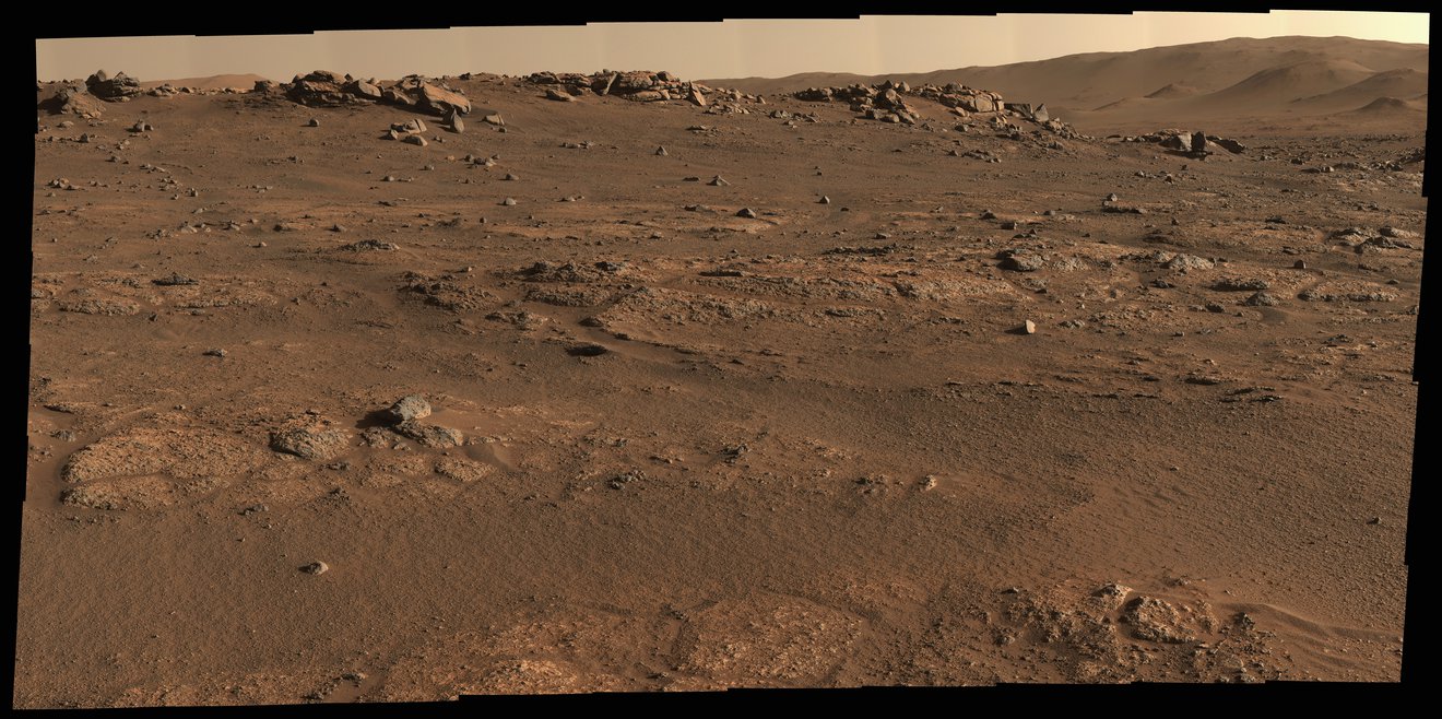 Perseverance Mars rover used its Mastcam-Z camera system to create this enhanced-color panorama, which scientists used to look for rock-sampling sites. The panorama is stitched together from 70 individual images taken on July 28, 2021, the 155th Martian day, or sol, of the mission.
Credit: NASA/JPL-Caltech/ASU/MSSS
Jim Bell at Arizona State University leads the Mastcam-Z team, which has been working at high speed to produce images for the larger group. “Part of our job on this mission has been a sort of triage,” he said. “We can swing through vast swaths of real estate and do some quick assessment of geology, of color. That has been helping the team figure out where to target instruments.”
Color is key: Mastcam-Z images allow scientists to make links between features seen from orbit by the Mars Reconnaissance Orbiter (MRO) and what they see on the ground.
The instrument also functions as a low-resolution spectrometer, dividing the light it captures into 11 colors. Scientists can analyze the colors for clues about the composition of the material giving off the light, helping them decide which features to zoom in on with the mission’s true spectrometers.
For instance, there’s a well-known series of images from March 17. It shows a wide escarpment, aka the “Delta Scarp,” that is part of a fan-shaped river delta that formed in the crater long ago. After Mastcam-Z provided the broad view, the mission turned to SuperCam for a closer look.
The Long View
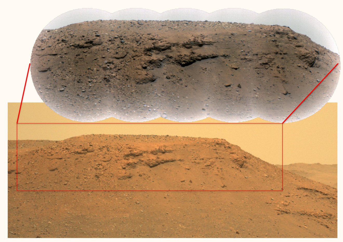 This image of an escarpment, or scarp – a long, steep slope – along the delta of Mars’ Jezero Crater was generated using data from the Perseverance rover’s Mastcam-Z instrument. The inset image at top is a close-up provided by the Remote Microscopic Imager, which is part of the SuperCam instrument.
Credit: RMI: NASA/JPL-Caltech/LANL/CNES/CNRS/ASU/MSSSMastcam-Z: NASA/JPL-Caltech/ASU/MSSS
Scientists use SuperCam to study mineralogy and chemistry, and to seek evidence of ancient microbial life. Perched near Mastcam-Z on Perseverance’s mast, it includes the Remote Micro-Imager, or RMI, which can zoom in on features the size of a softball from more than a mile away.
Once Mastcam-Z provided images of the scarp, the SuperCam RMI homed in on a corner of it, providing close-ups that were later stitched together for a more revealing view.
To Roger Wiens, principal investigator for SuperCam at Los Alamos National Laboratory in New Mexico, these images spoke volumes about Mars’ ancient past, when the atmosphere was thick enough, and warm enough, to allow water to flow on the surface.
“This is showing huge boulders,” he said. “That means there had to have been some huge flash flooding that occurred that washed boulders down the riverbed into this delta formation.”
The chock-a-block layers told him even more.
“These large boulders are partway down the delta formation,” Wiens said. “If the lakebed was full, you would find these at the very top. So the lake wasn’t full at the time the flash flood happened. Overall, it may be indicating an unstable climate. Perhaps we didn’t always have this very placid, calm, habitable place that we might have liked for raising some micro-organisms.”
In addition, scientists have picked up signs of igneous rock that formed from lava or magma on the crater floor during this early period. That could mean not only flowing water, but flowing lava, before, during, or after the time that the lake itself formed.
These clues are crucial to the mission’s search for signs of ancient Martian life and potentially habitable environments. To that end, the rover is taking samples of Martian rock and sediment that future missions could return to Earth for in-depth study.
The (Really) Close-up
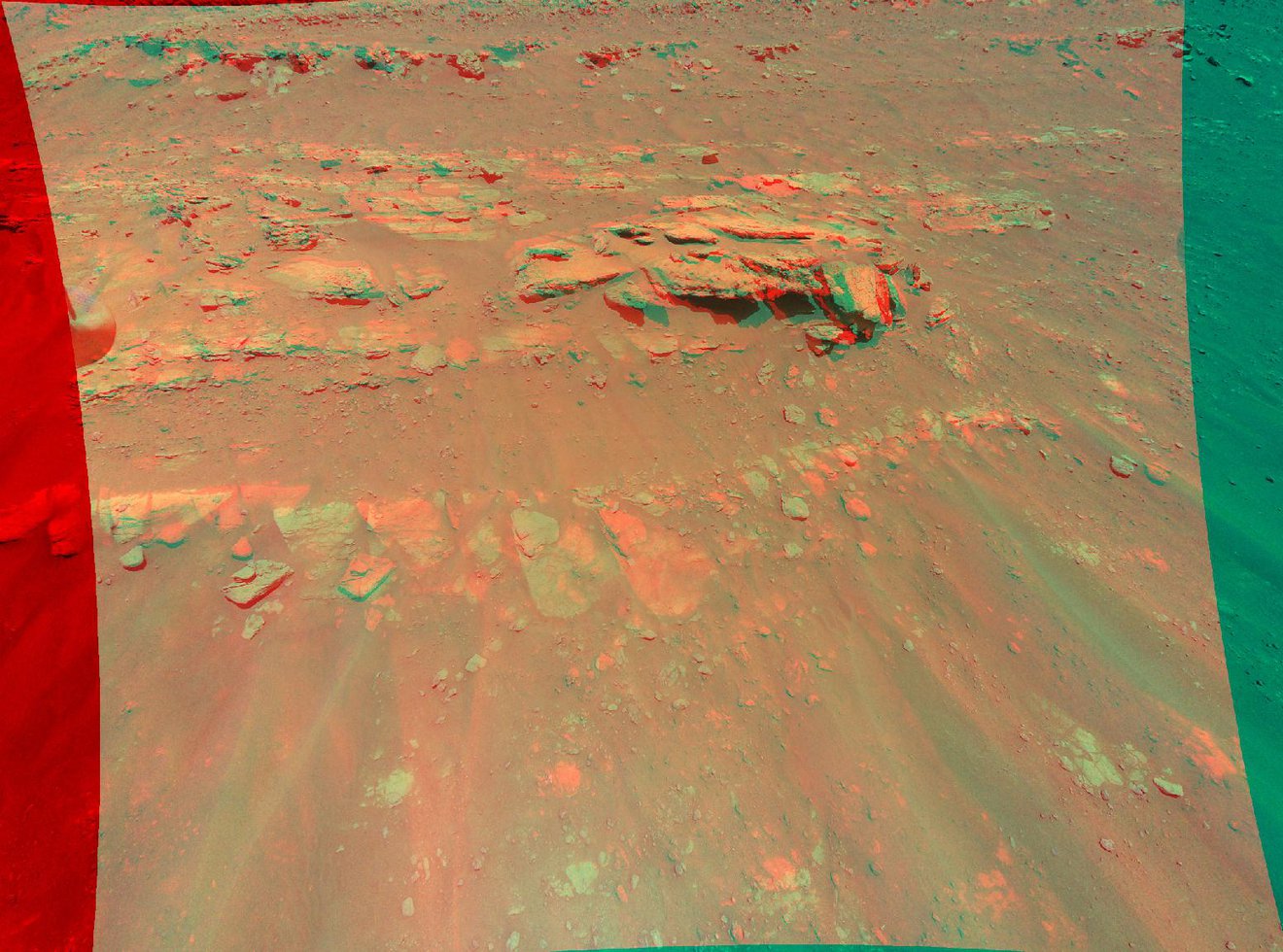
 Perseverance took this close-up of a rock target nicknamed “Foux” using its WATSON camera on July 11, 2021, the 139th Martian day, r sol, of the mission. The area within the camera is roughly 1.4 by 1 inches (3.5 centimeters by 2.6 centimeters).
Credit: NASA/JPL-Caltech/MSSS
A variety of Perseverance’s cameras assist in the selection of those samples, including WATSON (the Wide Angle Topographic Sensor for Operations and eNgineering).
Located at the end of the rover’s robotic arm, WATSON provides extreme closeups of rock and sediment, zeroing in on the variety, size, shape, and color of tiny grains – as well as the “cement” between them – in those materials. Such information can lend insight into Mars’ history as well as the geological context of potential samples.
WATSON also helps engineers position the rover’s drill for extracting rock core samples and produces images of where the sample came from.
The imager partners with SHERLOC (Scanning Habitable Environments with Raman & Luminescence for Organics & Chemicals), which includes an Autofocus and Contextual Imager (ACI), the rover’s highest-resolution camera. SHERLOC uses an ultraviolet laser to identify certain minerals in rock and sediment, while PIXL (Planetary Instrument for X-ray Lithochemistry), also on the robotic arm, uses X-rays to determine the chemical composition. These cameras, working in concert with WATSON, have helped capture geologic data – including signs of that igneous rock on the crater floor – with a precision that has surprised scientists.
“We’re getting really cool spectra of materials formed in aqueous [watery] environments – for example sulfate and carbonate,” said Luther Beegle, SHERLOC’s principal investigator at JPL.
Engineers also use WATSON to check on the rover’s systems and undercarriage – and to take Perseverance selfies (here’s how).
Beegle says not just the strong performance of the imaging instruments, but their ability to endure the harsh environment on the Martian surface, gives him confidence in Perseverance’s chances for major discoveries.
“Once we get over closer to the delta, where there should be really good preservation potential for signs of life, we’ve got a really good chance of seeing something if it’s there,” he said.
More About the Mission
A key objective for Perseverance’s mission on Mars is astrobiology, including the search for signs of ancient microbial life. The rover will characterize the planet’s geology and past climate, pave the way for human exploration of the Red Planet, and be the first mission to collect and cache Martian rock and regolith (broken rock and dust).
Subsequent NASA missions, in cooperation with ESA (European Space Agency), would send spacecraft to Mars to collect these sealed samples from the surface and return them to Earth for in-depth analysis.
The Mars 2020 Perseverance mission is part of NASA’s Moon to Mars exploration approach, which includes Artemis missions to the Moon that will help prepare for human exploration of the Red Planet.
JPL, which is managed for NASA by Caltech in Pasadena, California, built and manages operations of the Perseverance rover.
For more about Perseverance:
More About Perseverance
Where Is Perseverance Right Now?
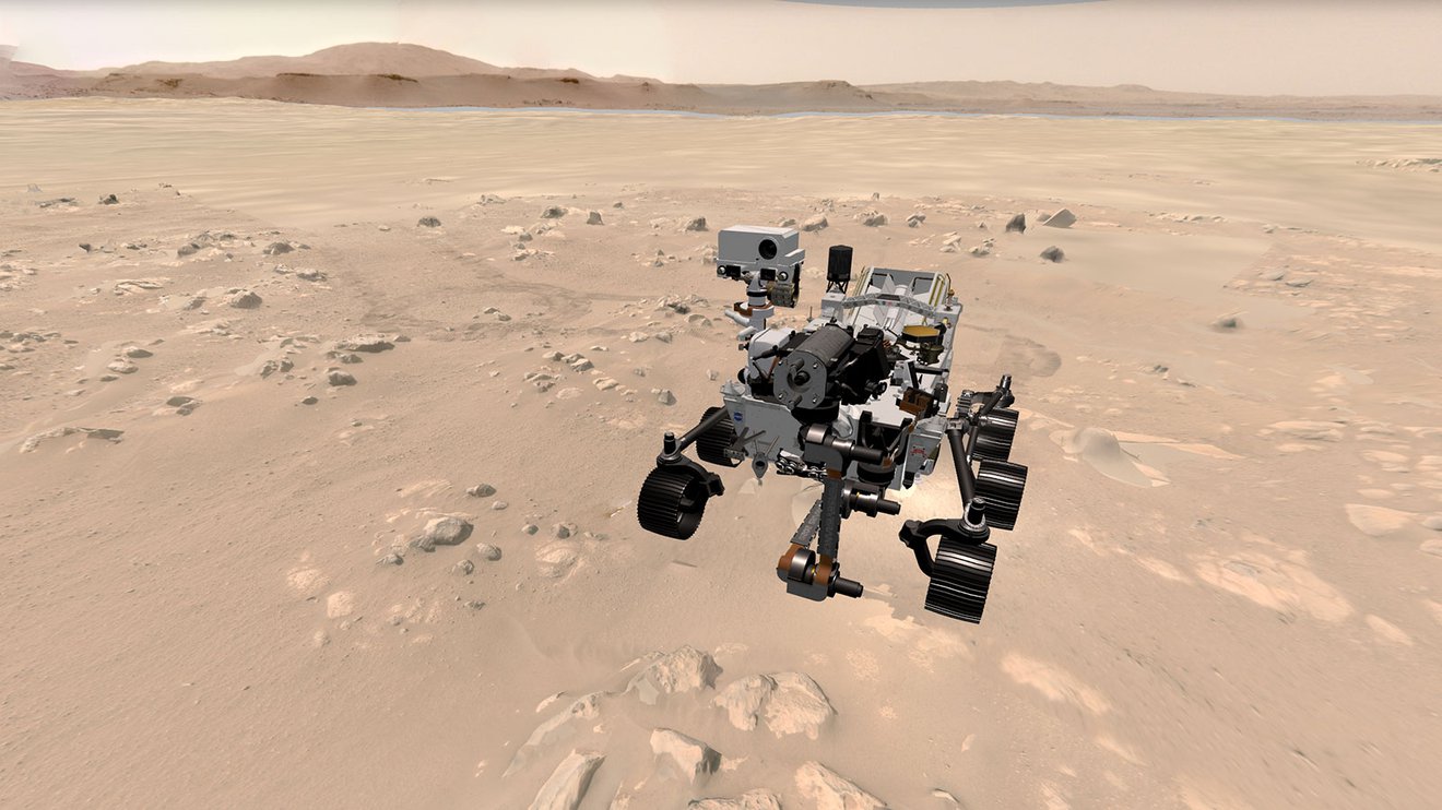
Explore With Perseverance in 3D
‘AR’ Mobile App Features 3D NASA Spacecraft
NASA’s Mars Rover Drivers Need Your Help
News Media Contact
DC Agle / Andrew Good
Jet Propulsion Laboratory, Pasadena, Calif.
818-393-9011 / 818-393-2433
agle@jpl.nasa.gov / andrew.c.good@jpl.nasa.gov
Karen Fox / Alana Johnson
NASA Headquarters, Washington
301-286-6284 / 202-358-1501
karen.c.fox@nasa.gov / alana.r.johnson@nasa.gov
Written by Pat Brennan
2021-199
For more information, please following the link:
Mars Perseverance Team Members to Be Recognized at Hispanic Heritage Awards
Sep 08, 2021
 From left to right: Diana Trujillo, Christina Hernandez, and Clara O’Farrell are engineers with NASA’s Mars Perseverance rover team.
Credit: Hispanic Heritage Foundation
The three award recipients – Diana Trujillo, Christina Hernandez, and Clara O’Farrell – are engineers from the NASA rover team.
Three Latina engineers at NASA’s Jet Propulsion Laboratory in Southern California are the 2021 recipients of STEM Awards from the Hispanic Heritage Foundation. They will be honored for their significant roles in the agency’s Mars 2020 Perseverance rover mission during the 34th Hispanic Heritage Awards broadcast on PBS Oct. 8, joined by Carlos Santana, Ivy Queen, and others.
NASA JPL recipients are:
- Christina Hernandez began her work at JPL in the Natural Space Environments group and as mission assurance manager on STABLE (Sub arcsecond Telescope and Balloon Experiment). Her Mars-related work began with impact assessment to keep Mars spacecraft safe during the Comet Siding Spring event. As a payload systems engineer for Perseverance, she has worked on three of its seven science instruments. Her work on the rover’s PIXL (short for Planetary Instrument for X-Ray Lithochemistry) will help scientists hunt for signs of ancient microbial life by taking super-close images of rock and soil textures and using its X-ray spectrometer to identify chemical elements within them.
- Clara O’Farrell, who is originally from Argentina, moved to the U.S. on her 19th birthday to start college. She studied aerospace engineering at Princeton and completed a doctoral degree at Caltech with research on fluid dynamics of jellyfish swimming. After joining JPL in 2013, she began her work on parachutes, aerodynamics, and trajectory simulation for Mars entry, descent, and landing. Her accomplishments as a guidance and control engineer include certifying a supersonic parachute to land Perseverance via supersonic sounding rocket tests.
- Diana Trujillo, an aerospace engineer, is currently Technical Group Supervisor for Sequence Planning and Execution and a Tactical Mission Lead for Perseverance. Born and raised in Colombia, Trujillo immigrated to the U.S. at the age of 17 to pursue her dream of working for NASA. While enrolled in English-as-a-second-language courses, she also worked full time to support her studies in community college and later the University of Florida and University of Maryland. Diana has held several roles for NASA and JPL, including Mars Curiosity Mission Lead, Deputy Project System Engineer, and Deputy Team Chief of Engineering Operations on Curiosity. Trujillo has also been active in sharing the excitement and opportunities of STEM with the public. She created and hosted #JuntosPerseveramos, NASA’s first-ever Spanish-language live broadcast of a major mission milestone (Perseverance landing on Mars), attracting millions of viewers worldwide.
“Congratulations to Christina, Clara, and Diana on receiving this prestigious STEM award,” said Dr. Jim Green, NASA’s chief scientist. “Each of them was integral to the planning, development, and successful landing of our Mars Perseverance rover. Our Mars Perseverance mission will advance NASA’s quest to explore past habitability of the Red Planet. Because of the hard work and dedication of our team, we can now look for past microbial life through the collection of core rock and soil samples and test technologies that will pave the way for future human exploration of Mars. Thank you to the Hispanic Heritage Foundation for their consideration and for this outstanding recognition of our extremely talented, diverse, and inspirational NASA workforce.”
Get the Latest JPL News
In the Hispanic Heritage Foundation’s news release, the organization’s president and CEO, Jose Antonio Tijerino, said, “As leaders in the STEM space, these inspirational Latinas demonstrate the great vision and value proposition our community presents America. These engineers also represent role models for aspiring Latinx engineers in expanding human knowledge and scientific discovery.”
The Hispanic Heritage Awards are produced by the Hispanic Heritage Foundation and were created by the White House in 1988 to commemorate the establishment of Hispanic Heritage Month in America. The awards are among the highest honors by Latinos for Latinos and are supported by 40 national Hispanic-serving institutions. The Foundation’s programs focus on education, workforce, and social impact through the lens of leadership.
More information at: https://www.hispanicheritage.org.
To learn more about Perseverance, visit:
and
https://mars.nasa.gov/mars2020/
News Media Contact
DC Agle / Andrew Good
Jet Propulsion Laboratory, Pasadena, Calif.
818-393-9011 / 818-393-2433
agle@jpl.nasa.gov / andrew.c.good@jpl.nasa.gov
2021-188
For more information, please following the link:
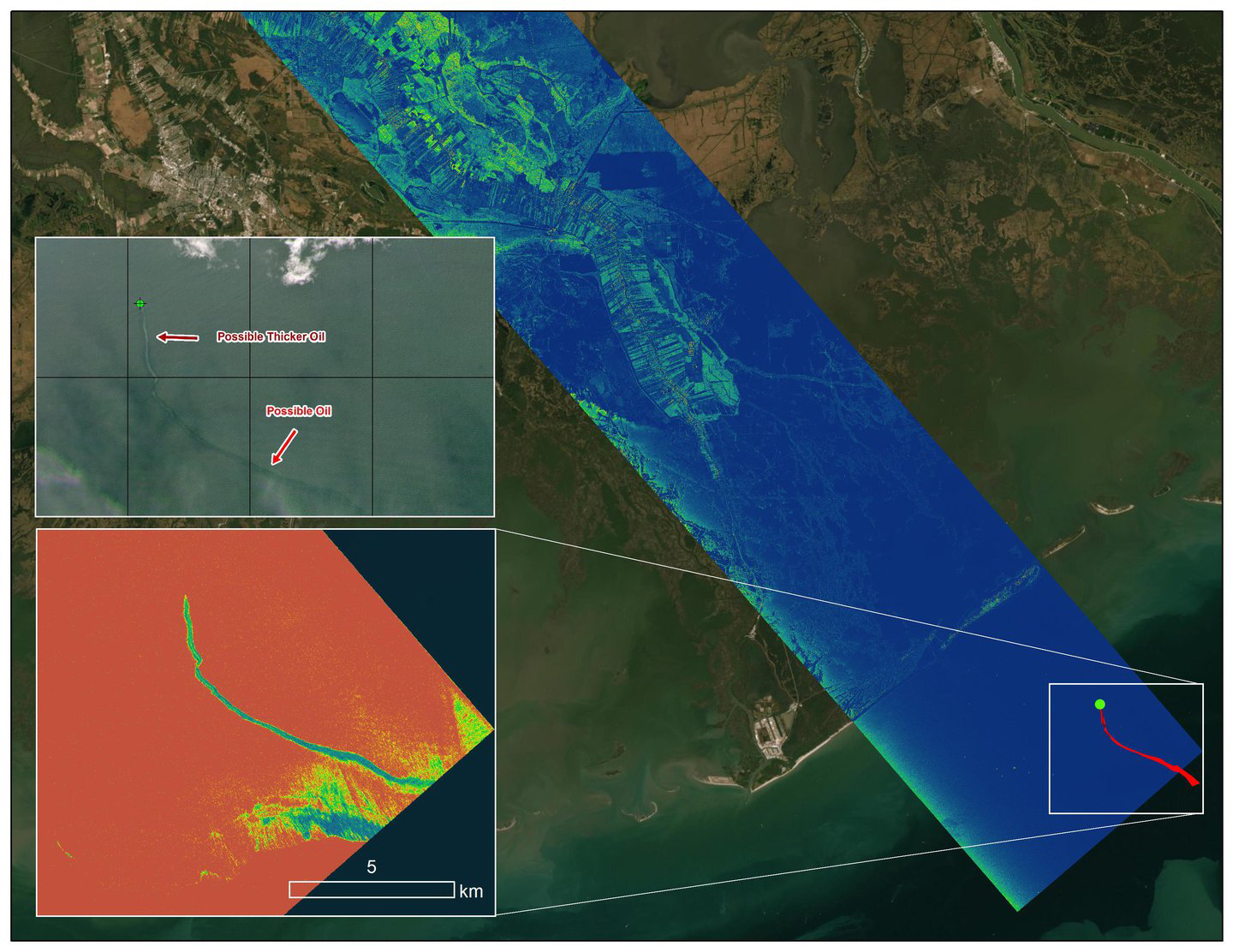
Delta-X Oil Slick Radar Signal in Gulf of Mexico
Sep 20, 2021
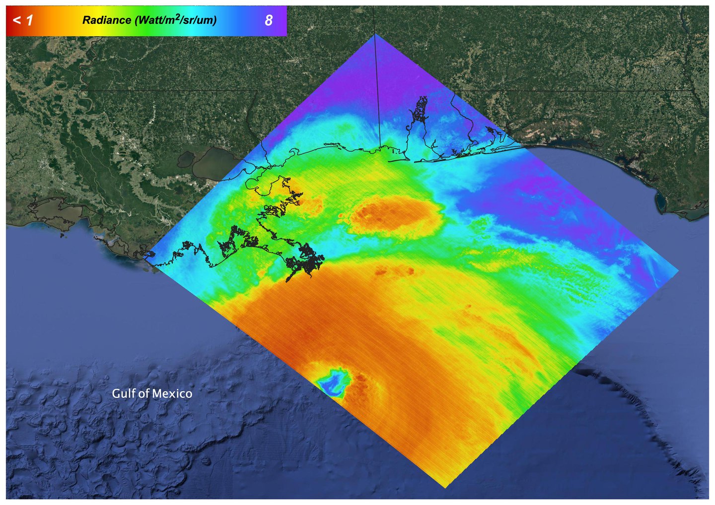
 An oil slick in the Gulf of Mexico following Hurricane Ida – a high-end Category 4 when it made landfall near Port Fourchon, Louisiana, on Aug. 29, 2021 – appears as a green trail in the inset false-color graphic provided by NASA’s Delta-X project, while the surrounding seawater appears orange. The National Oceanic and Atmospheric Administration (NOAA) regularly monitors U.S. coastal waters for potential spills and noticed slicks that appeared just off the coast after the hurricane. They were able to use this information from Delta-X to corroborate other data they had about oil slicks in the area (satellite image in the second inset picture). The blue-green swath crossing from the Gulf of Mexico over the Louisiana coast denotes the flight path of the Delta-X radar instrument on Sept. 1, just before 11:30 a.m. CDT.
Charged with studying the Mississippi River Delta, Delta-X was gearing up to collect data on Louisiana’s coastal wetlands when Hurricane Ida barreled ashore in late August. The storm damaged buildings and infrastructure alike, resulting in power outages, flooding, and oil slicks in the Gulf of Mexico.
Oil tends to smooth out the bumps on the ocean’s surface, which results in a distinct radar signal that the Delta-X mission was able to pick out of their data. Delta-X added flight paths to their planned schedule – with the support of NASA’s Applied Science Disaster Program – in order to collect information over the gulf in areas of interest to NOAA.
Delta-X is studying two wetlands – the Atchafalaya and Terrebonne Basins – by land, boat, and air to quantify water and sediment flow as well as vegetation growth. While the Atchafalaya Basin has been gaining land through sediment accumulation, Terrebonne Basin, which is right next to the Atchafalaya, has been rapidly losing land. The data collected by the project will be applied to models used to forecast which areas of the delta are likely to gain or lose land under various sea level rise, river flow, and watershed management scenarios.
The mission uses several instruments to collect its data. Affixed to the bottom of a Gulfstream-III airplane, one of those instruments, the all-weather Uninhabited Aerial Vehicle Synthetic Aperture Radar (UAVSAR), bounces radar signals off of Earth’s surface, forming a kind of image of a particular area. Repeated images of the same regions, captured at different times, enable researchers to detect changes in those areas, such as fluctuating water levels beneath the vegetation as the tides move in and out of these wetlands. In addition to radar measurements, teams from Caltech, Louisiana State University, Florida International University, and other collaborating institutions gather water and vegetation samples – among other data – by boat, other airborne sensors, and from instruments on the ground.
Funded by NASA’s Earth Venture Suborbital (EVS-3) program, Delta-X is managed by the agency’s Jet Propulsion Laboratory. Caltech in Pasadena, California, manages JPL for NASA. Fall 2021 was Delta-X’s last scheduled field campaign, although the five-year mission will run through the end of 2023.
To learn more about the Delta-X mission, visit: https://deltax.jpl.nasa.gov
Hurricane Ida, August 27, 2021
Oct 07, 2021
 https://www.jpl.nasa.gov/images/hurricane-ida-august-27-2021
On August 27, 2021 Ida crossed over Cuba as a Category 1 Storm. 48 hours later the storm intensified to a Category 4 before making landfall on the coast of Louisiana. The storm was the second most destructive storm to ever make landfall on the Louisiana coast with sustained winds over 150 mph (240 km/h).
The rapid intensification process that the storm system underwent is not well understood. Satellite images such as this are helpful as scientists attempt to understand new weather patterns that are emerging with Global Climate Change.
Tasked with detecting plant water use and stress, ECOSTRESS’s primary mission is to measure the temperature of plants heating up as they run out of water. But it can also measure and track heat-related phenomena like wildfires, heat waves, and volcanoes. ECOSTRESS observations have a spatial resolution of about 77 by 77 yards (70 by 70 meters), which enables researchers to study surface-temperature conditions down to the size of a football field. Due to the space station’s unique orbit, the mission can acquire images of the same regions at different times of the day, as opposed to crossing over each area at the same time of day like satellites in other orbits do. This is advantageous when monitoring plant stress in the same area throughout the day, for example.
The ECOSTRESS mission launched to the space station on June 29, 2018. NASA’s Jet Propulsion Laboratory, a division of Caltech in Pasadena, California, built and manages the mission for the Earth Science Division in the Science Mission Directorate at NASA Headquarters in Washington. ECOSTRESS is an Earth Venture Instrument mission; the program is managed by NASA’s Earth System Science Pathfinder program at NASA’s Langley Research Center in Hampton, Virginia.
More information about ECOSTRESS is available here: https://ecostress.jpl.nasa.gov/.
For more information, please following the link:
https://www.jpl.nasa.gov/images/delta-x-oil-slick-radar-signal-in-gulf-of-mexico
July 2021 Heat Wave Surface Temperature
Jul 15, 2021
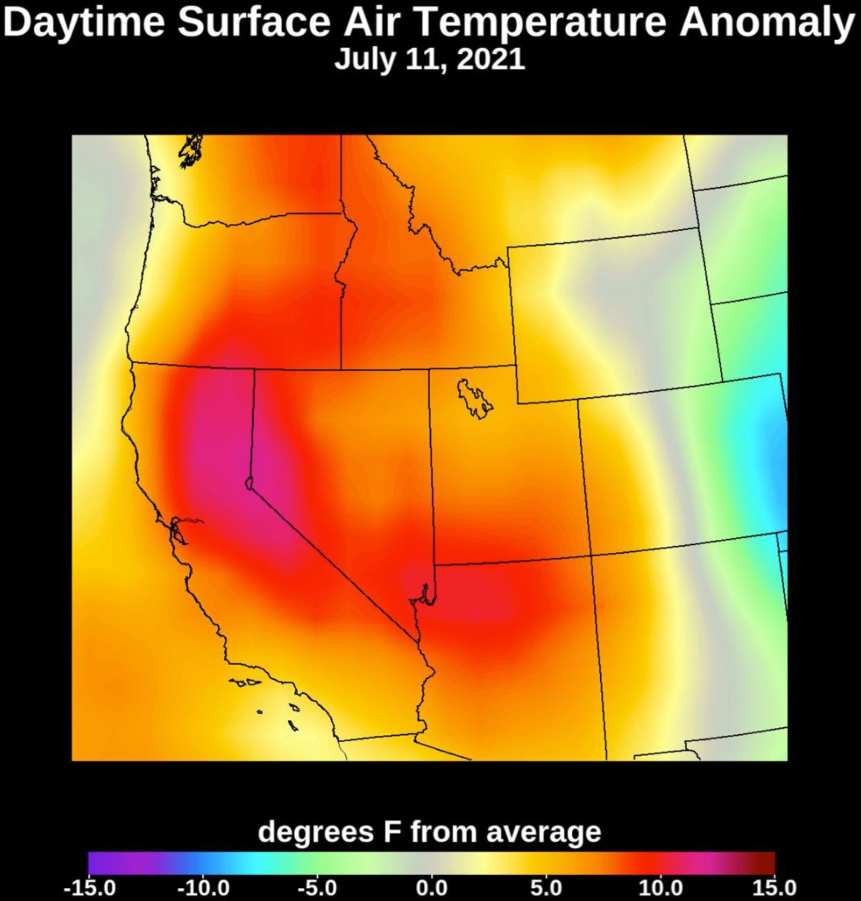
Collecting temperature readings in the atmosphere and at the surface, NASA’s Atmospheric Infrared Sounder (AIRS) instrument aboard the agency’s Aqua satellite captured the progression of a slow-moving heat dome across the southwestern U.S. from July 1 to July 12, 2021. The animation of the AIRS data shows surface air temperature anomalies – values above or below long-term averages. The hottest areas, shown in pink, experienced surface air temperatures more than 10 degrees Fahrenheit (5.6 degrees Celsius) above average. Surface air temperature is something that people directly feel when they are outside.
AIRS, in conjunction with the Advanced Microwave Sounding Unit (AMSU), senses emitted infrared and microwave radiation from Earth to provide a three-dimensional look at the planet’s weather and climate. Working in tandem, the two instruments make simultaneous observations down to Earth’s surface. With more than 2,000 channels sensing different regions of the atmosphere, the system creates a global, three-dimensional map of atmospheric temperature and humidity, cloud amounts and heights, greenhouse gas concentrations, and many other atmospheric phenomena. Launched into Earth orbit in 2002, the AIRS and AMSU instruments fly aboard NASA’s Aqua spacecraft and are managed by NASA’s Jet Propulsion Laboratory in Southern California, under contract to NASA. JPL is a division of Caltech.
More information about AIRS can be found at https://airs.jpl.nasa.gov.
For more information, please following the link:
https://www.jpl.nasa.gov/images/july-2021-heat-wave-surface-temperature
ECOSTRESS Views 2021 Northern California Dixie Fire
Jul 29, 2021
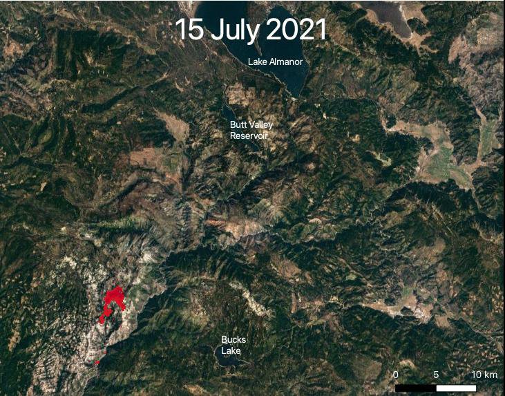
NASA’s ECOSTRESS captured data over Northern California’s Dixie Fire, which had ballooned to over 220,000 acres as of July 29, 2021. In the data visualization, the red areas show the hottest pixels – and fire movement – from July 15 to July 24. The most heavily affected areas are south of Lake Almanor in Plumas County.
Tasked with detecting plant water use and stress from the vantage point of the International Space Station, ECOSTRESS’s primary mission is to measure the temperature of plants heating up as they run out of water. But it can also measure and track heat-related phenomena like wildfires, heat waves, and volcanoes. ECOSTRESS observations have a spatial resolution of about 77 by 77 yards (70 by 70 meters), which enables researchers to study surface-temperature conditions down to the size of a football field. Due to the space station’s unique orbit, the mission can acquire images of the same regions at different times of the day, as opposed to crossing over each area at the same time of day like satellites in other orbits do. This is advantageous when monitoring plant stress in the same area throughout the day, for example.
The ECOSTRESS mission launched to the space station on June 29, 2018. NASA’s Jet Propulsion Laboratory, a division of Caltech in Pasadena, California, built and manages the mission for the Earth Science Division in the Science Mission Directorate at NASA Headquarters in Washington. ECOSTRESS is an Earth Venture Instrument mission; the program is managed by NASA’s Earth System Science Pathfinder program at NASA’s Langley Research Center in Hampton, Virginia.
More information about ECOSTRESS is available here: https://ecostress.jpl.nasa.gov/.
For more information, please following the link:
https://www.jpl.nasa.gov/images/ecostress-views-2021-northern-california-dixie-fire
ECOSTRESS Views 2021 Southern Oregon Bootleg Fire
Jul 29, 2021

NASA’s ECOsystem Spaceborne Thermal Radiometer Experiment on Space Station (ECOSTRESS) is aiding in the fight against fires in the Western U.S. As of July 27, 2021, the Bootleg Fire in southern Oregon had ballooned to more than 410,000 acres, damaging hundreds of buildings and vehicles in its path.
ECOSTRESS measures surface temperature from the vantage point of the International Space Station. Researchers of the RADR-Fire team at Pacific Northwest National Laboratory have been experimenting with ECOSTRESS data as part of a new tool now being implemented for first responders like the U.S. Forest Service.
In the visualization, ECOSTRESS is tracking the movement of the Bootleg Fire between July 7 and July and identifying its proximity to critical infrastructure — areas in red represent the hottest pixels ECOSTRESS detected. The extreme heat in those areas indicates the fire front, or where resources are most needed.
Tasked with detecting plant water use and stress, ECOSTRESS’s primary mission is to measure the temperature of plants heating up as they run out of water. But it can also measure and track heat-related phenomena like wildfires, heat waves, and volcanoes. ECOSTRESS observations have a spatial resolution of about 77 by 77 yards (70 by 70 meters), which enables researchers to study surface-temperature conditions down to the size of a football field. Due to the space station’s unique orbit, the mission can acquire images of the same regions at different times of the day, as opposed to crossing over each area at the same time of day like satellites in other orbits do. This is advantageous when monitoring plant stress in the same area throughout the day, for example.
The ECOSTRESS mission launched to the space station on June 29, 2018. NASA’s Jet Propulsion Laboratory, a division of Caltech in Pasadena, California, built and manages the mission for the Earth Science Division in the Science Mission Directorate at NASA Headquarters in Washington. ECOSTRESS is an Earth Venture Instrument mission; the program is managed by NASA’s Earth System Science Pathfinder program at NASA’s Langley Research Center in Hampton, Virginia.
More information about ECOSTRESS is available here: https://ecostress.jpl.nasa.gov/.
For more information, please following the link:
https://www.jpl.nasa.gov/images/ecostress-views-2021-southern-oregon-bootleg-fire
Leave a Reply