NASA’s Jet Propulsion Laboratory (JPL) Month in Review
MARS
NASA’s InSight ‘Hears’ Its First Meteoroid Impacts on Mars
Sept. 19, 2022
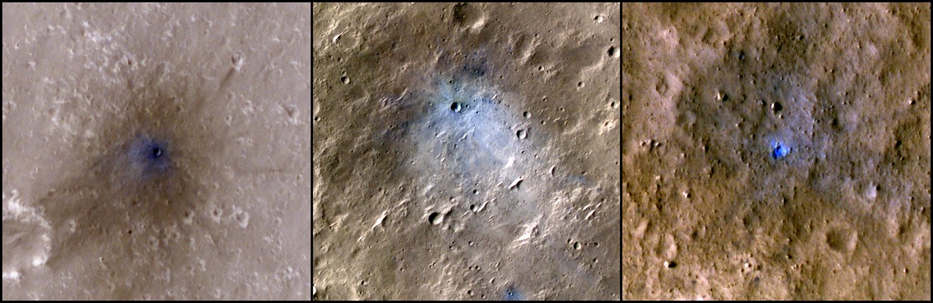
 These craters were formed by a Sept. 5, 2021, meteoroid impact on Mars, the first to be detected by NASA’s InSight. Taken by NASA’s Mars Reconnaissance Orbiter, this enhanced-color image highlights the dust and soil disturbed by the impact in blue in order to make details more visible to the human eye.
Credit: NASA/JPL-Caltech/University of Arizona
The Mars lander’s seismometer has picked up vibrations from four separate impacts in the past two years.
NASA’s InSight lander has detected seismic waves from four space rocks that crashed on Mars in 2020 and 2021. Not only do these represent the first impacts detected by the spacecraft’s seismometer since InSight touched down on the Red Planet in 2018, it also marks the first time seismic and acoustic waves from an impact have been detected on Mars.
A new paper published Monday in Nature Geoscience details the impacts, which ranged between 53 and 180 miles (85 and 290 kilometers) from InSight’s location, a region of Mars called Elysium Planitia.
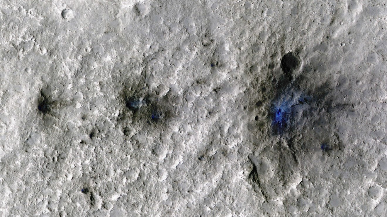
The first of the four confirmed meteoroids – the term used for space rocks before they hit the ground – made the most dramatic entrance: It entered Mars’ atmosphere on Sept. 5, 2021, exploding into at least three shards that each left a crater behind.
Learn more about the first meteoroid impact NASA’s InSight lander detected on Mars in this video.
Credit: NASA/JPL-Caltech
Then, NASA’s Mars Reconnaissance Orbiter flew over the estimated impact site to confirm the location. The orbiter used its black-and-white Context Camera to reveal three darkened spots on the surface. After locating these spots, the orbiter’s team used the High-Resolution Imaging Science Experiment camera, or HiRISE, to get a color close-up of the craters (the meteoroid could have left additional craters in the surface, but they would be too small to see in HiRISE’s images).
“After three years of InSight waiting to detect an impact, those craters looked beautiful,” said Ingrid Daubar of Brown University, a co-author of the paper and a specialist in Mars impacts.
After combing through earlier data, scientists confirmed three other impacts had occurred on May 27, 2020; Feb. 18, 2021; and Aug. 31, 2021.
Researchers have puzzled over why they haven’t detected more meteoroid impacts on Mars. The Red Planet is next to the solar system’s main asteroid belt, which provides an ample supply of space rocks to scar the planet’s surface. Because Mars’ atmosphere is just 1% as thick as Earth’s, more meteoroids pass through it without disintegrating.
InSight’s seismometer has detected over 1,300 marsquakes. Provided by France’s space agency, the Centre National d’Études Spatiales, the instrument is so sensitive that it can detect seismic waves from thousands of miles away. But the Sept. 5, 2021, event marks the first time an impact was confirmed as the cause of such waves.
InSight’s team suspects that other impacts may have been obscured by noise from wind or by seasonal changes in the atmosphere. But now that the distinctive seismic signature of an impact on Mars has been discovered, scientists expect to find more hiding within InSight’s nearly four years of data.
Listen to a Meteoroid Hitting the Red Planet
The sound of a meteoroid striking Mars – created from data recorded by NASA’s InSight lander – is like a “bloop” due to a peculiar atmospheric effect. In this audio clip, the sound can be heard three times: when the meteoroid enters the Martian atmosphere, explodes into pieces, and impacts the surface.
Credit: NASA/JPL-Caltech/CNES/IPGP
Science Behind the Strikes
Seismic data offer various clues that will help researchers better understand the Red Planet. Most marsquakes are caused by subsurface rocks cracking from heat and pressure. Studying how the resulting seismic waves change as they move through different material provides scientists a way to study Mars’ crust, mantle, and core.
The four meteoroid impacts confirmed so far produced small quakes with a magnitude of no more than 2.0. Those smaller quakes provide scientists with only a glimpse into the Martian crust, while seismic signals from larger quakes, like the magnitude 5 event that occurred in May 2022, can also reveal details about the planet’s mantle and core.
Read postcards people have sent to InSight
But the impacts will be critical to refining Mars’ timeline. “Impacts are the clocks of the solar system,” said the paper’s lead author, Raphael Garcia of Institut Supérieur de l’Aéronautique et de l’Espace in Toulouse, France. “We need to know the impact rate today to estimate the age of different surfaces.”
Scientists can approximate the age of a planet’s surface by counting its impact craters: The more they see, the older the surface. By calibrating their statistical models based on how often they see impacts occurring now, scientists can then estimate how many more impacts happened earlier in the solar system’s history.
InSight’s data, in combination with orbital images, can be used to rebuild a meteoroid’s trajectory and the size of its shock wave. Every meteoroid creates a shock wave as it hits the atmosphere and an explosion as it hits the ground. These events send sound waves through the atmosphere. The bigger the explosion, the more this sound wave tilts the ground when it reaches InSight. The lander’s seismometer is sensitive enough to measure how much the ground tilts from such an event and in what direction.
“We’re learning more about the impact process itself,” Garcia said. “We can match different sizes of craters to specific seismic and acoustic waves now.”
The lander still has time to study Mars. Dust buildup on the lander’s solar panels is reducing its power and will eventually lead to the spacecraft shutting down. Predicting precisely when is difficult, but based on the latest power readings, engineers now believe the lander could shut down between October of this year and January 2023.
More About the Mission
NASA’s Jet Propulsion Laboratory, a division of Caltech in Pasadena, California, manages InSight for the agency’s Science Mission Directorate in Washington. InSight is part of NASA’s Discovery Program, managed by the agency’s Marshall Space Flight Center in Huntsville, Alabama. Lockheed Martin Space in Denver built the InSight spacecraft, including its cruise stage and lander, and supports spacecraft operations for the mission.
A number of European partners, including France’s Centre National d’Études Spatiales (CNES) and the German Aerospace Center (DLR), are supporting the InSight mission. CNES provided the Seismic Experiment for Interior Structure (SEIS) instrument to NASA, with the principal investigator at IPGP (Institut de Physique du Globe de Paris). Significant contributions for SEIS came from IPGP; the Max Planck Institute for Solar System Research (MPS) in Germany; the Swiss Federal Institute of Technology (ETH Zurich) in Switzerland; Imperial College London and Oxford University in the United Kingdom; and JPL. DLR provided the Heat Flow and Physical Properties Package (HP3) instrument, with significant contributions from the Space Research Center (CBK) of the Polish Academy of Sciences and Astronika in Poland. Spain’s Centro de Astrobiología (CAB) supplied the temperature and wind sensors.
Hear Meteoroid Striking Mars, Captured by NASA’s InSight Lander
Sep 19, 2022 NASA Jet Propulsion Laboratory
NASA’s InSight lander detected seismic waves from a meteoroid and was able to capture the sound of the space rock striking the surface of Mars for the first time. The meteoroid – the term used for incoming space rocks before they hit the ground – entered Mars’ atmosphere on Sept. 5, 2021, exploding into at least three shards that each left craters behind. Mars’ atmosphere is just 1% as dense as Earth’s, allowing far more meteoroids to pass through and impact the Red Planet’s surface. This event marks the first time seismic and acoustic waves from an impact were detected on the Red Planet. Why does this meteoroid impact sound like a “bloop” in the video? It has to do with a peculiar atmospheric effect that’s also observed in deserts on Earth. After sunset, the atmosphere retains some heat accumulated during the day. Sound waves travel through this heated atmosphere at different speeds, depending on their frequency. As a result, lower-pitched sounds arrive before high-pitched sounds. An observer close to the impact would hear a “bang,” while someone many miles away would hear the bass sounds first, creating a “bloop.” NASA’s Mars Reconnaissance Orbiter flew over the estimated impact site to confirm the location. The orbiter used its black-and-white Context Camera to reveal three darkened spots on the surface. After locating these spots, the orbiter’s team used the High-Resolution Imaging Science Experiment camera, or HiRISE, to get a color close-up of the craters. Because HiRISE sees wavelengths the human eye can’t detect, scientists change the camera’s filters to enhance the color of the image. The areas that appear blue around the craters are where dust has been removed or disturbed by the blast of the impact. Martian dust is bright and red, so removing it makes the surface appear relatively dark and blue. For more information on InSight, visit https://mars.nasa.gov/insight/. Credit: NASA/JPL-Caltech/University of Maryland/University of Arizona/CNES/IPGP/Manchu/Bureau 21/ETH Zurich/Kirschner/van Driel
News Media Contact
Andrew Good
Jet Propulsion Laboratory, Pasadena, Calif.
818-393-2433
Karen Fox / Alana Johnson
NASA Headquarters, Washington
301-286-6284 / 202-358-1501
karen.c.fox@nasa.gov / alana.r.johnson@nasa.gov
2022-136
For more information, please visit the following link:
EARTH
NASA, USGS Map Minerals to Understand Earth Makeup, Climate ChangeSept. 30, 2022
Credit: NASA These new observations can be used to identify the presence of a wide variety of minerals as well as mineral weathering or alteration. NASA and the U.S. Geological Survey (USGS) will map portions of the southwest United States for critical minerals using advanced airborne imaging. Hyperspectral data from hundreds of wavelengths of reflected light can provide new information about Earth’s surface and atmosphere to help scientists understand Earth’s geology and biology, as well as the effects of climate change. The research project, called the Geological Earth Mapping Experiment (GEMx), will use NASA’s Airborne Visible/Infrared Imaging Spectrometer (AVIRIS) and Hyperspectral Thermal Emission Spectrometer (HyTES) instruments flown on NASA’s ER-2 and Gulfstream V aircraft to collect the measurements over the country’s arid and semi-arid regions, including parts of California, Nevada, Arizona, and New Mexico. “This exciting new project is just one example of the Biden-Harris Administration’s commitment to a clean energy future,” said NASA Administrator Bill Nelson. “NASA has a long history of Earth observation that shows us how the planet is responding to climate change. This project builds on our 60-year legacy, and can show us where to look for the resources that support our transition to a clean energy economy. With our partners at USGS, NASA has led the way in developing these Earth observation systems to gather information to measure and monitor the environment and climate change.” These new observations record the spectroscopic fingerprints of surface minerals across hundreds of wavelength bands. In other words, these are measurements not only of visible light our eyes can see but also of wavelengths of light beyond the visible into the infrared. The data can be used to identify the presence of a wide variety of minerals including primary rock-forming minerals as well as mineral weathering or alteration. This project will complement data from NASA’s newest instrument on the International Space Station, the Earth Surface Mineral Dust Source Investigation (EMIT). EMIT is focused on mapping the mineral dust source composition of Earth’s arid regions to better understand how mineral dust affects heating and cooling of the planet. The instrument also makes spectroscopic measurements of the hundreds of wavelengths of light reflected from materials on Earth. The mission provided its first view of Earth on July 27 and is expected to become fully operational next month. The $16 million GEMx research project will last five years and is funded by the USGS Earth Mapping Resources Initiative, through investments from the Bipartisan Infrastructure Law. The initiative will capitalize on both the technology developed by NASA for spectroscopic imaging as well as the expertise in analyzing the datasets and extracting critical mineral information from them. Beyond providing additional detail over the mineral maps made by EMIT, GEMx will provide NASA with critical high-resolution data at regional scales to support development of the Surface Biology and Geology mission, part of NASA’s new Earth System Observatory. The Surface Biology and Geology mission will answer questions about the fluxes of carbon, water, nutrients, and energy within and between ecosystems and the atmosphere, the ocean, and Earth. “This exciting scientific effort is made possible through the President Biden’s Bipartisan Infrastructure Law investments and will enable NASA and the USGS to leverage our unique capabilities toward a common goal,” said USGS Director David Applegate. “The data we’re collecting will be foundational for not only critical minerals research but also for a wide range of other scientific applications, from natural hazards mitigation to ecosystem restoration.” In 1979, NASA started developing spectral imaging systems at the Jet Propulsion Laboratory. The first system, the Airborne Imaging Spectrometer, led to the development of AVIRIS. NASA and USGS have a long history of collaborating on collecting and analyzing spectroscopic data, including the 17-year Earth Observing-1 mission, which carried the first Earth orbiting instrument spanning the AVIRIS spectral range, Hyperion. This type of spectroscopic imaging has a long history of use in mineral research. These data are also useful for understanding a variety of other Earth science, ecological, and biological issues including geological acid mine drainage, debris flows, agriculture, wildfires, and biodiversity. For more information about NASA’s Earth science programs, visit: News Media ContactTylar Greene NASA Headquarters, Washington 202-358-0030 2022-141 For more information, please visit the following link: https://www.jpl.nasa.gov/news/nasa-usgs-map-minerals-to-understand-earth-makeup-climate-change?utm_source=iContact&utm_medium=email&utm_campaign=nasajpl&utm_content=monthly20220930-11 |
|
| SOLAR SYSTEM
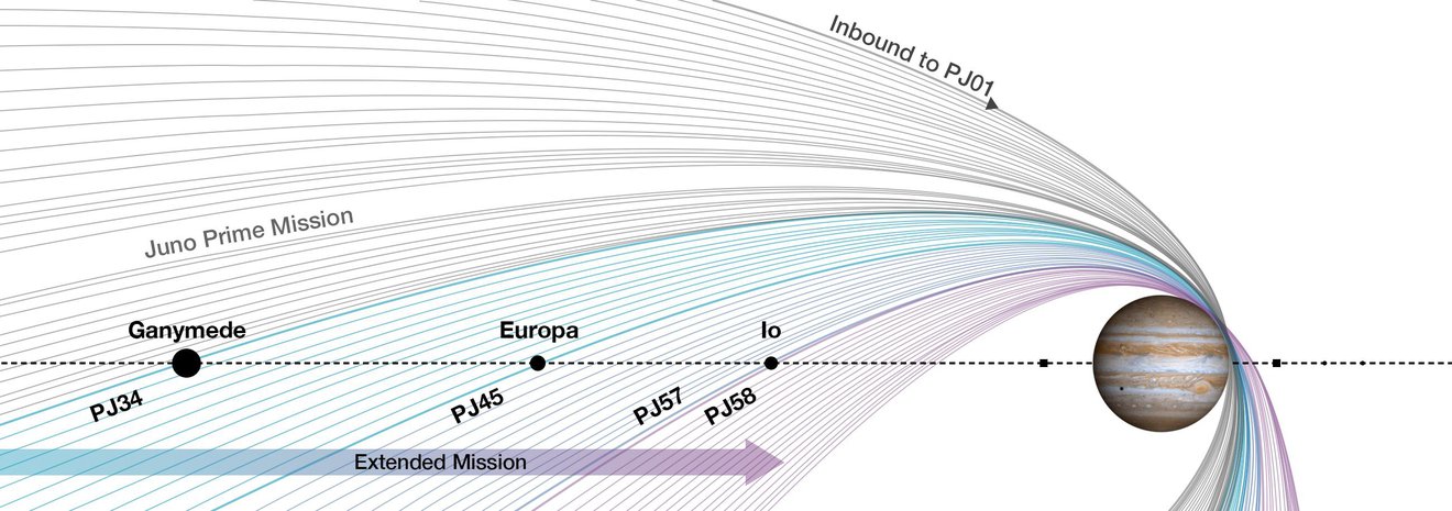
NASA’s Juno Shares First Image From Flyby of Jupiter’s Moon Europa Sept. 29, 2022 Observations from the spacecraft’s pass of the moon provided the first close-up in over two decades of this ocean world, resulting in remarkable imagery and unique science.
Credit: NASA/JPL-Caltech/SWRI/MSSS Lee esta nota de prensa en español aquí The first picture NASA’s Juno spacecraft took as it flew by Jupiter’s ice-encrusted moon Europa has arrived on Earth. Revealing surface features in a region near the moon’s equator called Annwn Regio, the image was captured during the solar-powered spacecraft’s closest approach, on Thursday, Sept. 29, at 2:36 a.m. PDT (5:36 a.m. EDT), at a distance of about 219 miles (352 kilometers). This is only the third close pass in history below 310 miles (500 kilometers) altitude and the closest look any spacecraft has provided at Europa since Jan. 3, 2000, when NASA’s Galileo came within 218 miles (351 kilometers) of the surface. Europa is the sixth-largest moon in the solar system, slightly smaller than Earth’s moon. Scientists think a salty ocean lies below a miles-thick ice shell, sparking questions about potential conditions capable of supporting life underneath Europa’s surface. This segment of the first image of Europa taken during this flyby by the spacecraft’s JunoCam (a public-engagement camera) zooms in on a swath of Europa’s surface north of the equator. Due to the enhanced contrast between light and shadow seen along the terminator (the nightside boundary), rugged terrain features are easily seen, including tall shadow-casting blocks, while bright and dark ridges and troughs curve across the surface. The oblong pit near the terminator might be a degraded impact crater. Find out where Juno is right now with NASA’s interactive Eyes on the Solar System. With its blades stretching out some 66 feet (20 meters), the spacecraft is a dynamic engineering marvel, spinning to keep itself stable as it orbits Jupiter and flies by some of the planet’s moons. Credit: NASA/JPL-Caltech With this additional data about Europa’s geology, Juno’s observations will benefit future missions to the Jovian moon, including the agency’s Europa Clipper. Set to launch in 2024, Europa Clipper will study the moon’s atmosphere, surface, and interior, with its main science goal being to determine whether there are places below Europa’s surface that could support life. As exciting as Juno’s data will be, the spacecraft had only a two-hour window to collect it, racing past the moon with a relative velocity of about 14.7 miles per second (23.6 kilometers per second). “It’s very early in the process, but by all indications Juno’s flyby of Europa was a great success,” said Scott Bolton, Juno principal investigator from Southwest Research Institute in San Antonio. “This first picture is just a glimpse of the remarkable new science to come from Juno’s entire suite of instruments and sensors that acquired data as we skimmed over the moon’s icy crust.” During the flyby, the mission collected what will be some of the highest-resolution images of the moon (0.6 miles, or 1 kilometer, per pixel) and obtained valuable data on Europa’s ice shell structure, interior, surface composition, and ionosphere, in addition to the moon’s interaction with Jupiter’s magnetosphere. Images of Ganymede from Juno’s 2021 flyby “The science team will be comparing the full set of images obtained by Juno with images from previous missions, looking to see if Europa’s surface features have changed over the past two decades,” said Candy Hansen, a Juno co-investigator who leads planning for the camera at the Planetary Science Institute in Tucson, Arizona. “The JunoCam images will fill in the current geologic map, replacing existing low-resolution coverage of the area.” Juno’s close-up views and data from its Microwave Radiometer (MWR) instrument will provide new details on how the structure of Europa’s ice varies beneath its crust. Scientists can use all this information to generate new insights into the moon, including data in the search for regions where liquid water may exist in shallow subsurface pockets. Building on Juno’s observations and previous missions such as Voyager 2 and Galileo, NASA’s Europa Clipper mission, slated to arrive at Europa in 2030, will study the moon’s atmosphere, surface, and interior – with a goal to investigate habitability and better understand its global subsurface ocean, the thickness of its ice crust, and search for possible plumes that may be venting subsurface water into space. The close flyby modified Juno’s trajectory, reducing the time it takes to orbit Jupiter from 43 to 38 days. The flyby also marks the second encounter with a Galilean moon during Juno’s extended mission. The mission explored Ganymede in June 2021 and is scheduled to make close flybys of Io, the most volcanic body in the solar system, in 2023 and 2024. More About the Mission NASA’s Jet Propulsion Laboratory, a division of Caltech in Pasadena, California, manages the Juno mission for the principal investigator, Scott J. Bolton, of the Southwest Research Institute in San Antonio. Juno is part of NASA’s New Frontiers Program, which is managed at NASA’s Marshall Space Flight Center in Huntsville, Alabama, for the agency’s Science Mission Directorate in Washington. Lockheed Martin Space in Denver built and operates the spacecraft. More information about Juno is available at: and https://www.missionjuno.swri.edu News Media ContactDC Agle Jet Propulsion Laboratory, Pasadena, Calif. 818-393-9011 Karen Fox / Alana Johnson NASA Headquarters, Washington 301-286-6284 / 202-358-1501 karen.c.fox@nasa.gov / alana.r.johnson@nasa.gov Deb Schmid Southwest Research Institute, San Antonio 210-522-2254 2022-140 For more information, please visit the following link:
WEATHER |
|

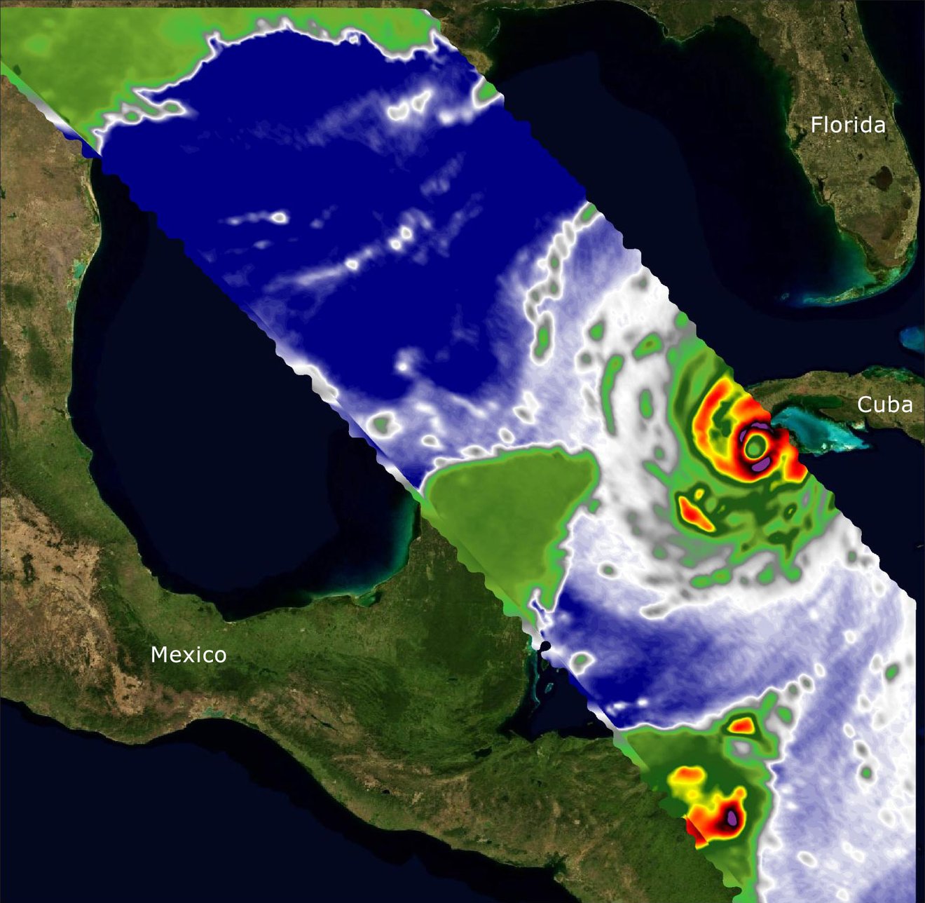
| NASA-Built Weather Sensors Capture Vital Data on Hurricane Ian
Sept. 28, 2022
Credit: NASA/JPL-Caltech A pair of microwave radiometers collected data on the storm as they passed over the Caribbean Sea aboard the International Space Station. Two recently launched instruments that were designed and built at NASA’s Jet Propulsion Laboratory in Southern California to provide forecasters data on weather over the open ocean captured images of Hurricane Ian on Tuesday, Sept. 27, 2022, as the storm approached Cuba on its way north toward the U.S. mainland. COWVR (short for Compact Ocean Wind Vector Radiometer) and TEMPEST (Temporal Experiment for Storms and Tropical Systems) observe the planet’s atmosphere and surface from aboard the International Space Station, which passed in low-Earth orbit over the Caribbean Sea at about 12:30 a.m. EDT. Ian made landfall in Cuba’s Pinar del Rio province at 4:30 a.m. EDT, according to the National Hurricane Center. At that time, it was a Category 3 hurricane, with estimated wind speeds of 125 mph (205 kph). The image above combines microwave emissions measurements from both COWVR and TEMPEST. White sections indicate the presence of clouds. Green portions indicate rain. Yellow, red, and black indicate where air and water vapor were moving most swiftly. Ian’s center is seen just off of Cuba’s southern coast, and the storm is shown covering the island with rain and wind. COWVR and TEMPEST sent the data for this image back to Earth in a direct stream via NASA’s tracking and data relay satellite (TDRS) constellation. The data were processed at JPL and made available to forecasters less than two hours after collection. About the size of a minifridge, COWVR measures natural microwave emissions over the ocean. The magnitude of the emissions increases with the amount of rain in the atmosphere, and the strongest rain produces the strongest microwave emissions. TEMPEST – comparable in size to a cereal box – tracks microwaves at a much shorter wavelength, allowing it to see ice particles within the hurricane’s cloudy regions that are thrust into the upper atmosphere by the storm. Both microwave radiometers were conceived to demonstrate that smaller, more energy-efficient, more simply designed sensors can perform most of the same measurements as current space-based weather instruments that are heavier, consume more power, and cost much more to construct. COWVR’s development was funded by the U.S. Space Force, and TEMPEST was developed with NASA funding. The U.S. Space Test Program-Houston 8 (STP-H8) is responsible for hosting the instruments on the space station under Space Force funding in partnership with NASA. Data from the instruments is being used by government and university weather forecasters and scientists. The mission will inform development of future space-based weather sensors, and scientists are working on mission concepts that would take advantage of the low-cost microwave sensor technologies to study long-standing questions, such as how heat from the ocean fuels global weather patterns. News Media ContactAndrew Wang / Jane J. Lee Jet Propulsion Laboratory, Pasadena, Calif. 626-379-6874 / 818-354-0307 andrew.wang@jpl.nasa.gov / jane.j.lee@jpl.nasa.gov 2022-139 For more information, please visit the following link:
|
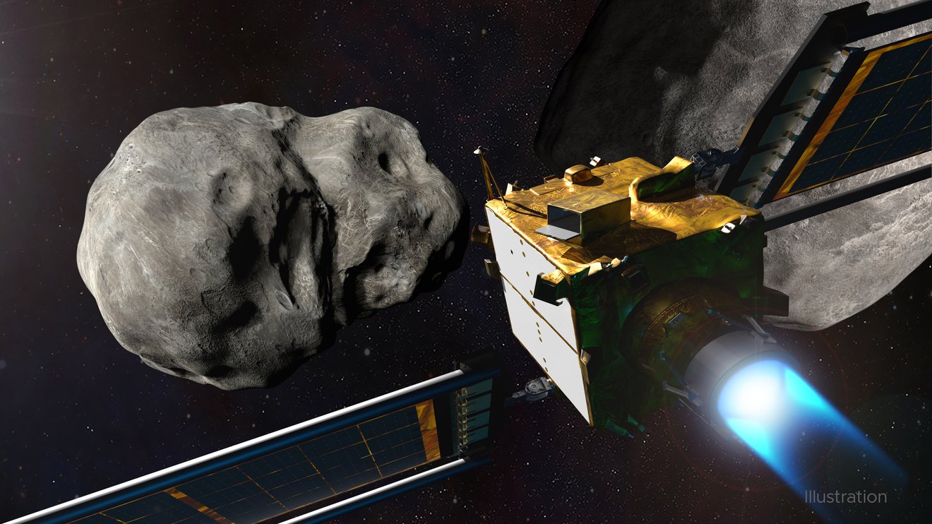
ASTEROIDS AND COMETSNASA’s Asteroid-Striking DART Mission Team Has JPL MembersSept. 22, 2022
Credit: NASA/Johns Hopkins APL/Steve Gribben It’s a bold and complex undertaking to try impacting an asteroid. JPL is there to assist with navigators, communications, and more. On Monday, Sept. 26, NASA’s Double Asteroid Redirection Test (DART) mission has the challenging goal of crashing its spacecraft into Dimorphos, a small moonlet orbiting a larger asteroid by the name of Didymos. While the asteroid poses no threat to Earth, this mission will test technology that could be used to defend our planet against potential asteroid or comet hazards that may be detected in the future. Johns Hopkins Applied Physics Laboratory (APL) in Laurel, Maryland, designed and leads the ambitious mission for NASA. But as with many missions, the endeavor calls on expertise from various NASA centers. In the case of the agency’s Jet Propulsion Laboratory in Southern California, that expertise is for navigation, precise location of the target, asteroid science, and Earth-to-spacecraft communications. “Strategic partnerships like ours with APL are the lifeblood of cutting-edge space mission development,” said Laurie Leshin, director of JPL. “Our history of working with APL goes all the way back to Voyager and extends well into the future, with missions like Europa Clipper. The work we do together makes us all – and our missions – better. We’re proud to support the DART mission and team.” Teachable Moment Launched in November 2021, the approximately 1,320-pound (about 600-kilogram) DART spacecraft will be at a point 6.8 million miles (11 million kilometers) from Earth when it impacts Dimorphos, which is just 525 feet (160 meters) across. Making matters more challenging still, the spacecraft will be closing in on the space rock at about 4 miles (6.1 kilometers) per second. Dimorphos orbits Didymos, which is roughly half a mile (780 meters) in diameter, every 11.9 hours. Getting to Dimorphos JPL’s navigation section is experienced at getting spacecraft to faraway locations accurately (think: Cassini to Saturn, Juno to Jupiter, Perseverance to Mars). Each mission brings its own set of challenges, and DART has many. “It’s a difficult job,” said JPL’s Julie Bellerose, who leads the DART spacecraft navigation team. “A big part of what the navigation team is working on is getting DART to a 9-mile-wide (15-kilometer-wide) box in space 24 hours before impact.” At that point, Bellerose said, the mission’s final trajectory correction maneuver (the firing of thrusters to modify the direction of flight) will be executed by mission controllers back on Earth. From then on, it’s up to DART. During the final hours of its one-way journey, DART will utilize an autonomous onboard navigator created by APL to stay on course. SMART Nav, or Small-body Maneuvering Autonomous Real Time Navigation, collects and processes images of Didymos and Dimorphos from DART’s DRACO (Didymos Reconnaissance and Asteroid Camera for Optical navigation) high-resolution camera, and then uses a set of computational algorithms to determine what maneuvering needs to be done in the final four hours before impact. Along with the DART team, another set of JPL navigators is calculating and planning the trajectory of DART’s spacecraft companion: The Italian Space Agency’s (ASI) Light Italian CubeSat for Imaging Asteroids, or LICIACube, which has the important task of imaging DART’s impact effects on Dimorphos. The toaster-size spacecraft disconnected from DART on Sept. 11 to navigate interplanetary space on its own – with an assist from the team at JPL. “We are working with ASI to get LICIACube to within 25 to 50 miles (40 to 80 kilometers) of Dimorphos just two to three minutes after DART’s impact – close enough to get good images of the impact and ejecta plume, but not so close LICIACube could be hit by ejecta,” said JPL’s LICIACube navigation lead Dan Lubey. While not necessary for the DART mission to succeed, the pre- and post-impact images this small satellite’s two optical cameras LEIA (LICIACube Explorer Imaging for Asteroid) and LUKE (LICIACube Unit Key Explorer) will provide could benefit the scientific community for studies of near-Earth objects and aid in the interpretation of the DART results. Time and Space JPL’s Center for Near Earth Object Studies (CNEOS), an element of NASA’s Planetary Defense Coordination Office (PDCO), was tasked with determining not only the location of Didymos in space to within 16 miles (25 kilometers), but also when Dimorphos would be visible – and accessible – from DART’s direction of approach. Along with investigators at other institutions, members of CNEOS will study the plume of rock and regolith (broken rock and dust) ejected by the impact, as well as the newly formed impact crater and the movement of Dimorphos in its orbit around its parent asteroid. Led by JPL’s Steve Chesley, they will not only examine data and imagery from DART and LICIACube, but also data from space and ground-based telescopes. Scientists think the impact should shorten the moonlet’s orbital period around the larger asteroid by several minutes. That duration should be long enough for the effects to be observed and measured by telescopes on Earth. It should also be enough for this test to demonstrate whether kinetic impact technology – impacting an asteroid to adjust its speed and therefore its path – could in fact protect Earth from an asteroid strike. Important contributors among those Earth-based telescopes include NASA’s Deep Space Network, the array of giant radio telescope dishes that JPL manages. With radar observations led by JPL scientist Shantanu Naidu, the massive 70-meter (230-foot) dish of Deep Space Station 14 at the network’s Goldstone complex near Barstow, California, will begin observing the aftermath of the celestial collision about 11 hours after impact, when Earth’s rotation brings Didymos and Dimorphos into view of Goldstone. Data from the echoes bounced off the two space rocks should help determine what changes occurred in the moonlet’s orbit and may even provide some coarse-resolution radar images. Of course, radio science is only part of the Deep Space Network’s role. The navigation teams depend on it as well because the network is the means by which NASA has been communicating with spacecraft at the Moon and beyond since 1963. More About the Mission Johns Hopkins APL manages the DART mission for PDCO as a project of the agency’s Planetary Missions Program Office. DART is the world’s first planetary defense test mission, intentionally executing a kinetic impact into Dimorphos to slightly change its motion in space. While the asteroid does not pose any threat to Earth, the DART mission will demonstrate that a spacecraft can autonomously navigate to a kinetic impact on a relatively small asteroid and prove this is a viable technique to deflect an asteroid on a collision course with Earth if one is ever discovered. DART will reach its target on Sept. 26, 2022. ASI’s LICIACube mission is operated by Argotec with independent navigation provided by JPL, the University of Bologna, and Politecnico di Milano. LICIACube rode along with DART throughout launch and cruise and then was released 15 days before DART’s impact. LICIACube’s mission focuses on imaging the results of the DART’s impact (the crater and ejecta plume) as well as the unimpacted side of Dimorphos. News Media ContactDC Agle / Ian J. O’Neill Jet Propulsion Laboratory, Pasadena, Calif. 818-393-9011 / 818-354-2649 agle@jpl.nasa.gov / ian.j.oneill@jpl.nasa.gov Josh Handal NASA Headquarters, Washington 202-358-2307 Justyna Surowiec / Michael Buckley Johns Hopkins Applied Physics Laboratory 240-302-9268 / 240-228-7536 justyna.surowiec@jhuapl.edu / michael.buckley@jhuapl.edu 2022-137 For more information, please visit the following link: |
SOLAR SYSTEM
NASA’s Juno Will Perform Close Flyby of Jupiter’s Icy Moon EuropaSept. 22, 2022
Credit: Image data: NASA/JPL-Caltech/SwRI/MSSS. Image processing: Andrea Luck CC BY As the spacecraft makes a close approach of the moon, it is expected to provide valuable science – and remarkable imagery – for NASA’s upcoming Europa Clipper mission. On Thursday, Sept. 29, at 2:36 a.m. PDT (5:36 a.m. EDT), NASA’s Juno spacecraft will come within 222 miles (358 kilometers) of the surface of Jupiter’s ice-covered moon, Europa. The solar-powered spacecraft is expected to obtain some of the highest-resolution images ever taken of portions of Europa’s surface, as well as collect valuable data on the moon’s interior, surface composition, and ionosphere, along with its interaction with Jupiter’s magnetosphere. Such information could benefit future missions, including the agency’s Europa Clipper, which is set to launch in 2024 to study the icy moon. “Europa is such an intriguing Jovian moon, it is the focus of its own future NASA mission,” said Juno Principal Investigator Scott Bolton of the Southwest Research Institute in San Antonio. “We’re happy to provide data that may help the Europa Clipper team with mission planning, as well as provide new scientific insights into this icy world.”
Credit: NASA/JPL-Caltech/SwRI With an equatorial diameter of 1,940 miles (3,100 kilometers), Europa is about 90% the size of Earth’s Moon. Scientists think a salty ocean lies below a miles-thick ice shell, sparking questions about potential conditions capable of supporting life underneath Europa’s surface. The close flyby will modify Juno’s trajectory, reducing the time it takes to orbit Jupiter from 43 to 38 days. It will be the closest a NASA spacecraft has approached Europa since Galileo came within 218 miles (351 kilometers) on Jan. 3, 2000. In addition, this flyby marks the second encounter with a Galilean moon during Juno’s extended mission. The mission explored Ganymede in June 2021 and plans to make close approaches of Io in 2023 and 2024. Data collection will begin an hour prior to closest approach, when the spacecraft is 51,820 miles (83,397 kilometers) from Europa. “The relative velocity between spacecraft and moon will be 14.7 miles per second (23.6 kilometers per second), so we are screaming by pretty fast,” said John Bordi, Juno deputy mission manager at JPL. “All steps have to go like clockwork to successfully acquire our planned data, because soon after the flyby is complete, the spacecraft needs to be reoriented for our upcoming close approach of Jupiter, which happens only 7 ½ hours later.” Find out where Juno is right now with NASA’s interactive Eyes on the Solar System. With its three giant blades stretching out some 66 feet (20 meters), the spacecraft is a dynamic engineering marvel, spinning to keep itself stable as it makes oval-shaped orbits around Jupiter. Credit: NASA/JPL-Caltech The spacecraft’s full suite of instruments and sensors will be activated for the Europa encounter. Juno’s Jupiter Energetic-Particle Detector Instrument (JEDI) and its medium-gain (X-band) radio antenna will collect data on Europa’s ionosphere. Its Waves, Jovian Auroral Distributions Experiment (JADE), and Magnetometer (MAG) experiments will measure plasma in the moon’s wake as Juno explores Europa’s interaction with Jupiter’s magnetosphere. MAG and Waves will also search for possible water plumes above Europa’s surface. “We have the right equipment to do the job, but to capture a plume will require a lot of luck,” said Bolton. “We have to be at the right place at just the right time, but if we are so fortunate, it’s a home run for sure.” See raw images from the spacecraft’s JunoCam imager Inside and Out Juno’s Microwave Radiometer (MWR) will peer into Europa’s water-ice crust, obtaining data on its composition and temperature. This is the first time such data will have been collected to study the moon’s icy shell. In addition, the mission expects to take four visible-light images of the moon with JunoCam (a public-engagement camera) during the flyby. The Juno science team will compare them to images from previous missions, looking for changes in Europa’s surface features that might have occurred over the past two decades. These visible-light images will have an expected resolution better than 0.6 miles (1 kilometer) per pixel. Although Juno will be in Europa’s shadow when closest to the moon, Jupiter’s atmosphere will reflect enough sunlight for Juno’s visible-light imagers to collect data. Designed to take images of star fields and search for bright stars with known positions to help Juno get its bearings, the mission’s star camera (called the Stellar Reference Unit) will take a high-resolution black-and-white image of Europa’s surface. Meanwhile, the Jovian Infrared Auroral Mapper (JIRAM) will attempt to collect infrared images of its surface. Juno’s closeup views and data from its MWR instrument will inform the Europa Clipper mission, which will perform nearly 50 flybys after it arrives at Europa in 2030. Europa Clipper will gather data on the moon’s atmosphere, surface, and interior – information that scientists will use to better understand Europa’s global subsurface ocean, the thickness of its ice crust, and possible plumes that may be venting subsurface water into space. More About the Mission NASA’s Jet Propulsion Laboratory, a division of Caltech in Pasadena, California, manages the Juno mission for the principal investigator, Scott J. Bolton, of the Southwest Research Institute in San Antonio. Juno is part of NASA’s New Frontiers Program, which is managed at NASA’s Marshall Space Flight Center in Huntsville, Alabama, for the agency’s Science Mission Directorate in Washington. Lockheed Martin Space in Denver built and operates the spacecraft. More information about Juno is available at: and https://www.missionjuno.swri.edu News Media ContactDC Agle Jet Propulsion Laboratory, Pasadena, Calif. 818-393-9011 Karen Fox / Alana Johnson NASA Headquarters, Washington 301-286-6284 / 202-358-1501 karen.c.fox@nasa.gov / alana.r.johnson@nasa.gov Deb Schmid Southwest Research Institute, San Antonio 210-522-2254 2022-138 For more information, please visit the following link: |

 VIDEO
VIDEO
What’s Up: October 2022
The Orionid meteor shower peaks in late October, and Mars appears to halt its usual eastward motion, wandering toward the west for a bit.
What are some skywatching highlights in October 2022? Enjoy giant planets Jupiter and Saturn all night throughout the month. Then watch as Mars begins its retrograde motion, moving westward each night instead of eastward, for the next few months. Finally, check out the Orionid meteors overnight on Oct. 20.
Transcript:
What’s Up for October? Evenings with giants, Mars changes course, and meteors from Orion.
Giant planets Jupiter and Saturn are visible throughout the night in October. Early in the evening, you’ll find them to the southeast, moving slowly westward with the stars over the course of the night. They form a triangle with bright star Fomalhaut.
When observing this trio, note how the planets shine with a steady light, while the star twinkles. This can be an easy way to know if what you’re looking at is a planet or a star.
Mars has been steadily working its way toward the east all year like it usually does, relative to the background stars. But at the end of October, Mars halts this apparent motion, and then appears to reverse course. Over the next three months, from November to late January, Mars moves toward the west each night. Then near the end of January, it reverses direction again, and continues its eastward journey.
This is what’s called the retrograde motion of Mars. It happens about every two years, and it really threw early observers for a loop. That Mars appears to change its direction is an illusion caused by the motions of our planet in its orbit passing by the Red Planet in its orbit.
See, Earth and Mars are on these roughly circular paths around the Sun, like cars on a racetrack, and Earth is on the inner, faster track. About every 26 months, we overtake Mars, which is moving slower in its orbit. During that period when we’re passing Mars, and before we round the bend in our orbit to pull away from it, we see Mars in retrograde, appearing to change direction, even though it’s still moving forward in its orbit.
So take note of Mars over the next few months, as it appears to reverse course. Note how its position changes with respect to Betelgeuse, Aldebaran and the Pleiades over the weeks, and you’ll be witnessing what was once a source of intense curiosity for astronomers, but which we now know is just a sign of two planets passing in the night.
The Orionid meteor shower is active throughout October and November, and peaks on the night of October 20. It’s a moderate shower, usually producing 10-20 meteors per hour at its peak, under clear, dark skies. This year, the Moon will be about 20 percent full on the peak nights. So it will interfere a bit when it rises a couple of hours before dawn, but shouldn’t totally spoil the viewing.
The shower’s name comes from the fact that you can trace the paths of its meteors back to an area on the sky near Orion. These meteors are fragments of dust left behind by Comet Halley in a trail that extends along its orbit. They tend to be bright and fast moving, and they often leave persistent trails that can glow in the sky for a few seconds after they streak by.
No special equipment is needed to observe meteor showers. Just make sure you’re warm enough, and viewing from a safe, dark spot away from bright lights. Then all you have to do is look up and enjoy the show.
Here are the phases of the Moon for October. Stay up to date with all of NASA’s missions to explore the solar system and beyond at nasa.gov. I’m Preston Dyches from NASA’s Jet Propulsion Laboratory, and that’s What’s Up for this month.
For more information, please visit the following link:
What’s Up: October 2022 Skywatching Tips from NASA
Sep 30, 2022 NASA Jet Propulsion Laboratory
NASA Jet Propulsion Laboratory
What are some skywatching highlights in October 2022? Enjoy giant planets Jupiter and Saturn all night throughout the month. Then watch as Mars begins its retrograde motion, moving westward each night instead of eastward, for the next few months. Finally, check out the Orionid meteors overnight on Oct. 20. 0:00 Intro 0:11 Evenings with Jupiter & Saturn 0:37 Mars’ retrograde motion 2:07 Orionid meteor shower 3:04 October Moon phases Additional information about topics covered in this episode of What’s Up, along with still images from the video, and the video transcript, are available at https://solarsystem.nasa.gov/skywatch…. — Additional Resources — Skywatching resources from NASA: https://solarsystem.nasa.gov/skywatch… NASA “Watch the Skies” blog: https://blogs.nasa.gov/Watch_the_Skies/ NASA’s Night Sky Network: https://nightsky.jpl.nasa.gov/
Chapters
Intro 0:00Evenings with Jupiter & Saturn 0:11
Mars’ retrograde motion 0:37
Orionid meteor shower 2:07
October Moon phases 3:04
Mars
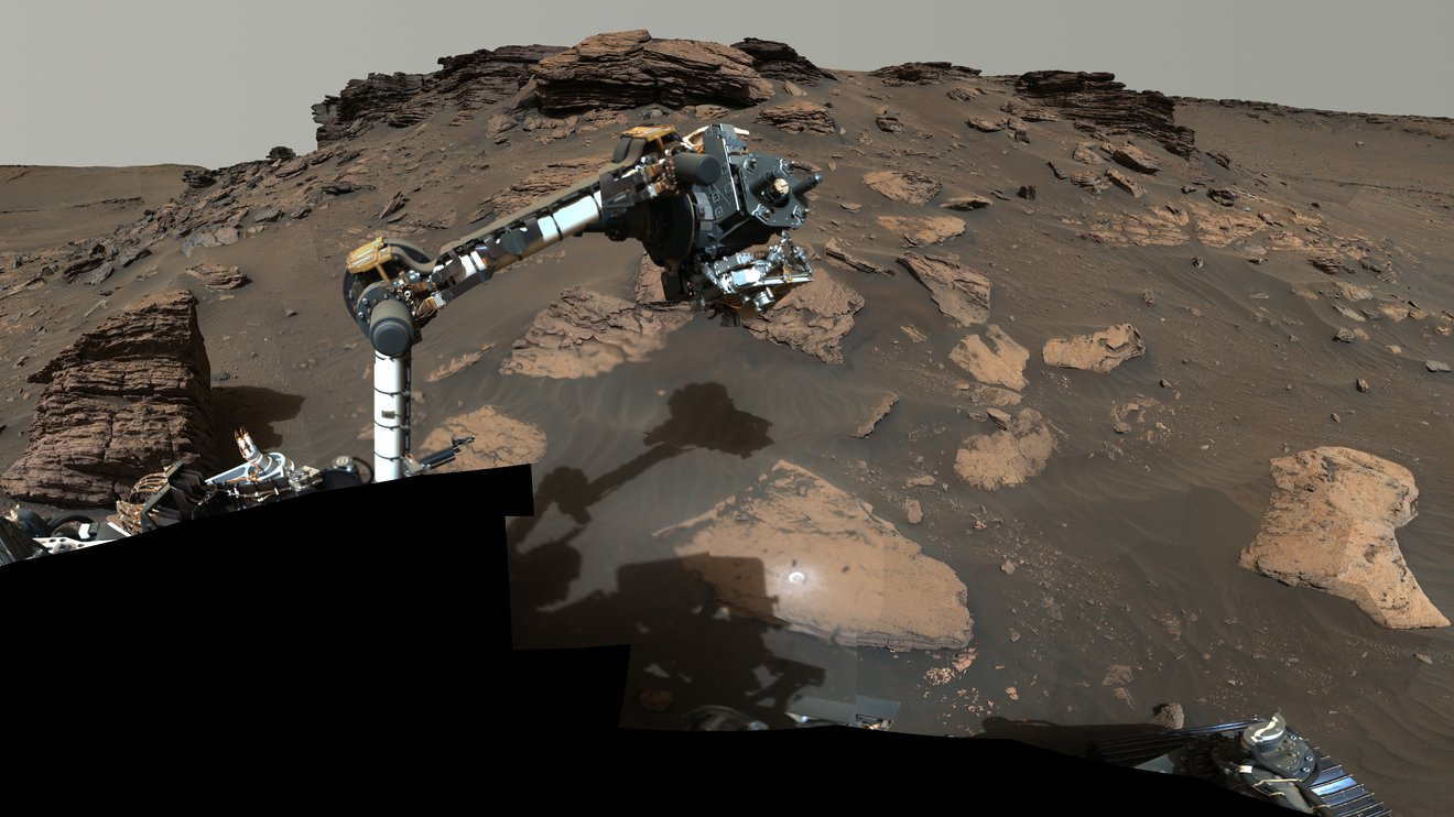
NASA’s Perseverance Rover Investigates Geologically Rich Mars Terrain
| Sept. 15, 2022
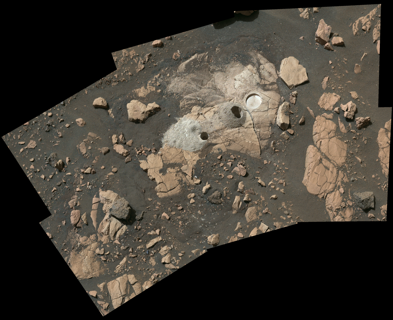
Credit: NASA/JPL-Caltech/ASU/MSSS The latest findings provide greater detail on a region of the Red Planet that has a watery past and is yielding promising samples for the NASA-ESA Mars Sample Return campaign. NASA’s Perseverance rover is well into its second science campaign, collecting rock-core samples from features within an area long considered by scientists to be a top prospect for finding signs of ancient microbial life on Mars. The rover has collected four samples from an ancient river delta in the Red Planet’s Jezero Crater since July 7, bringing the total count of scientifically compelling rock samples to 12. “We picked the Jezero Crater for Perseverance to explore because we thought it had the best chance of providing scientifically excellent samples – and now we know we sent the rover to the right location,” said Thomas Zurbuchen, NASA’s associate administrator for science in Washington. “These first two science campaigns have yielded an amazing diversity of samples to bring back to Earth by the Mars Sample Return campaign.” Twenty-eight miles (45 kilometers) wide, Jezero Crater hosts a delta – an ancient fan-shaped feature that formed about 3.5 billion years ago at the convergence of a Martian river and a lake. Perseverance is currently investigating the delta’s sedimentary rocks, formed when particles of various sizes settled in the once-watery environment. During its first science campaign, the rover explored the crater’s floor, finding igneous rock, which forms deep underground from magma or during volcanic activity at the surface. “The delta, with its diverse sedimentary rocks, contrasts beautifully with the igneous rocks – formed from crystallization of magma – discovered on the crater floor,” said Perseverance project scientist Ken Farley of Caltech in Pasadena, California. “This juxtaposition provides us with a rich understanding of the geologic history after the crater formed and a diverse sample suite. For example, we found a sandstone that carries grains and rock fragments created far from Jezero Crater – and a mudstone that includes intriguing organic compounds.”
Credit: NASA/JPL-Caltech/ASU/MSSS “Wildcat Ridge” is the name given to a rock about 3 feet (1 meter) wide that likely formed billions of years ago as mud and fine sand settled in an evaporating saltwater lake. On July 20, the rover abraded some of the surface of Wildcat Ridge so it could analyze the area with the instrument called Scanning Habitable Environments with Raman & Luminescence for Organics & Chemicals, or SHERLOC. SHERLOC’s analysis indicates the samples feature a class of organic molecules that are spatially correlated with those of sulfate minerals. Sulfate minerals found in layers of sedimentary rock can yield significant information about the aqueous environments in which they formed. The most detailed panorama ever returned from Mars – combining 1,118 images taken by the Mastcam-Z instrument on NASA’s Perseverance rover in June 2022 – reveals the intriguing landscape of Jezero Crater’s delta. In this video, rover science operations team member Rachel Kronyak gives a tour of the panorama. Credit: NASA/JPL-Caltech/ASU/MSSS What Is Organic Matter? Organic molecules consist of a wide variety of compounds made primarily of carbon and usually include hydrogen and oxygen atoms. They can also contain other elements, such as nitrogen, phosphorus, and sulfur. While there are chemical processes that produce these molecules that don’t require life, some of these compounds are the chemical building blocks of life. The presence of these specific molecules is considered to be a potential biosignature – a substance or structure that could be evidence of past life but may also have been produced without the presence of life. In 2013, NASA’s Curiosity Mars rover found evidence of organic matter in rock-powder samples, and Perseverance has detected organics in Jezero Crater before. But unlike that previous discovery, this latest detection was made in an area where, in the distant past, sediment and salts were deposited into a lake under conditions in which life could potentially have existed. In its analysis of Wildcat Ridge, the SHERLOC instrument registered the most abundant organic detections on the mission to date. See more images from the Perseverance mission Where Is Perseverance Right Now? Explore with Perseverance in 3D “In the distant past, the sand, mud, and salts that now make up the Wildcat Ridge sample were deposited under conditions where life could potentially have thrived,” said Farley. “The fact the organic matter was found in such a sedimentary rock – known for preserving fossils of ancient life here on Earth – is important. However, as capable as our instruments aboard Perseverance are, further conclusions regarding what is contained in the Wildcat Ridge sample will have to wait until it’s returned to Earth for in-depth study as part of the agency’s Mars Sample Return campaign.” The first step in the NASA-ESA (European Space Agency) Mars Sample Return campaign began when Perseverance cored its first rock sample in September 2021. Along with its rock-core samples, the rover has collected one atmospheric sample and two witness tubes, all of which are stored in the rover’s belly. The geologic diversity of the samples already carried in the rover is so good that the rover team is looking into depositing select tubes near the base of the delta in about two months. After depositing the cache, the rover will continue its delta explorations. “I’ve studied Martian habitability and geology for much of my career and know first-hand the incredible scientific value of returning a carefully collected set of Mars rocks to Earth,” said Laurie Leshin, director of NASA’s Jet Propulsion Laboratory. “That we are weeks from deploying Perseverance’s fascinating samples and mere years from bringing them to Earth so scientists can study them in exquisite detail is truly phenomenal. We will learn so much.” More About the Mission A key objective for Perseverance’s mission on Mars is astrobiology, including caching samples that may contain signs of ancient microbial life. The rover will characterize the planet’s geology and past climate, pave the way for human exploration of the Red Planet, and be the first mission to collect and cache Martian rock and regolith. Subsequent NASA missions, in cooperation with ESA, would send spacecraft to Mars to collect these sealed samples from the surface and return them to Earth for in-depth analysis. The Mars 2020 Perseverance mission is part of NASA’s Moon to Mars exploration approach, which includes Artemis missions to the Moon that will help prepare for human exploration of the Red Planet. JPL, which is managed for NASA by Caltech, built and manages operations of the Perseverance rover. Perseverance Explores the Jezero Crater DeltaSep 14, 2022 NASA Jet Propulsion Laboratory NASA’s Perseverance Mars Rover has arrived at an ancient delta in Jezero Crater, one of the best places on the Red Planet to search for potential signs of ancient life. The delta is an area where scientists surmise that a river once flowed billions of years ago into a lake and deposited sediments in a fan shape. Rachel Kronyak, a member of the Perseverance science operations team, guides the viewer through this Martian panorama and its intriguing sedimentary rocks. It’s the most detailed view ever returned from the Martian surface, consisting of 2.5 billion pixels and generated from 1,118 individual Mastcam-Z images. Those images were acquired on June 12, 13, 16, 17, and 20, 2022 (the 466th, 467th, 470th, 471st, and 474th Martian day, or sol, of Perseverance’s mission). In this panorama, an area called Hogwallow Flats is visible, as is Skinner Ridge, where two rock core samples were taken. The color enhancement in this image improves the visual contrast and accentuates color differences. This makes it easier for the science team to use their everyday experience to interpret the landscape. For more information on the Perseverance rover, visit https://mars.nasa.gov/perseverance. Credit: NASA/JPL-Caltech/ASU/MSSS Locations View suggestions on Google Maps
|


WEATHERNASA’s AIRS Instrument Records Typhoon Hinnamnor Before LandfallSept. 8, 2022
Credit: NASA/JPL-Caltech The Atmospheric Infrared Sounder aboard the Aqua satellite captured the outer bands of the powerful tropical cyclone as the storm approached the Korean Peninsula. NASA’s Atmospheric Infrared Sounder (AIRS) instrument aboard the Aqua satellite captured imagery of Typhoon Hinnamnor in the West Pacific Ocean just before 2 p.m. local time on Sept. 5. Typhoon Hinnamnor was one of the strongest in South Korea’s recorded history, dropping some 40 inches (102 centimeters) of rain and unleashing record winds. In an infrared image from AIRS, the typhoon can be seen moving northward over the Korean Peninsula, with the coast of China to the west and the southernmost Japanese islands to the east. The large purple area of the image indicates very cold clouds at about minus 90 degrees Fahrenheit (minus 67 degrees Celsius), carried high into the atmosphere by deep thunderstorms. These storm clouds are associated with heavy rainfall. The image’s extensive areas of red beyond the storm indicate temperatures of around 80 F (26 C), typical of Earth’s daytime surface during late summer. These areas are mostly cloud-free, with the clear air caused by air motion outward from the cold clouds in the storm center then downward in the surrounding areas. U.S. Hurricane Hunter planes don’t monitor the vast expanse of the Pacific Ocean, so AIRS and other satellite instruments are essential for tracking typhoons as they grow. AIRS, launched in 2002, was the first instrument to reveal the 3D distribution of rain within tropical storms like Hinnamnor. These 3D images have made a major contribution to knowledge of how hurricanes and typhoons develop, improving forecasts and saving lives. One of six instruments aboard Aqua, AIRS provides data that is improving weather forecasts and advancing our understanding of Earth’s climate. AIRS, along with its partner microwave instrument the Advanced Microwave Sounding Unit, AMSU-A, was a generational advancement in atmospheric sounding systems at its launch and has provided two decades of high-quality atmospheric observations. These instruments are part of NASA’s larger Earth observing fleet, which works to measure components of the global water and energy cycles, climate variation and trends, and the response of the climate system to increased greenhouse gases. AIRS, in conjunction with AMSU-A, senses infrared and microwave radiation emitted from Earth to provide a 3D look at the planet’s weather and climate, making observations down to Earth’s surface. With more than 2,000 channels sensing different regions of the atmosphere, the system creates a global, 3D map of atmospheric temperature and humidity, cloud amounts and heights, greenhouse gas concentrations, and many other atmospheric phenomena. AIRS is managed by NASA’s Jet Propulsion Laboratory in Southern California, a division of Caltech. More information about AIRS can be found at: News Media ContactJane J. Lee / Andrew Wang Jet Propulsion Laboratory, Pasadena, Calif. 818-354-0307 / 626-379-6874 jane.j.lee@jpl.nasa.gov / andrew.wang@jpl.nasa.gov Written by Sally Younger 2022-133 For more information, please visit the following link: |

STARS AND GALAXIES
A Cosmic Tarantula, Caught by NASA’s Webb
Sept. 6, 2022
 In this mosaic image stretching 340 light-years across, Webb’s Near-Infrared Camera (NIRCam) displays the Tarantula Nebula star-forming region in a new light, including tens of thousands of never-before-seen young stars that were previously shrouded in cosmic dust.
Credit: NASA, ESA, CSA, STScI, Webb ERO Production Team
The cycle of star formation is on display in this nearby nebula. Webb’s MIRI instrument captures protostars nestled deep in clouds of gas and dust, still gathering mass.
Once upon a space-time, a cosmic creation story unfolded: thousands of never-before-seen young stars spotted in a stellar nursery called 30 Doradus, captured by NASA’s James Webb Space Telescope. Nicknamed the Tarantula Nebula for the appearance of its dusty filaments in previous telescope images, the nebula has long been a favorite for astronomers studying star formation. In addition to young stars, Webb reveals distant background galaxies, as well as the detailed structure and composition of the nebula’s gas and dust.
At only 161,000 light-years away in the Large Magellanic Cloud galaxy, the Tarantula Nebula is the largest and brightest star-forming region in the Local Group, the galaxies nearest our Milky Way. It is home to the hottest, most massive stars known. Astronomers focused three of Webb’s high-resolution infrared instruments on the Tarantula. Viewed with Webb’s Near-Infrared Camera (NIRCam), the region resembles a burrowing tarantula’s home, lined with its silk. The nebula’s cavity centered in the NIRCam image has been hollowed out by blistering radiation from a cluster of massive young stars, which sparkle pale blue in the image. Only the densest surrounding areas of the nebula resist erosion by these stars’ powerful stellar winds, forming pillars that appear to point back toward the cluster. These pillars contain forming protostars, which will eventually emerge from their dusty cocoons and take their turn shaping the nebula.
 At the longer wavelengths of light captured by its Mid-Infrared Instrument (MIRI), Webb focuses on the area surrounding the central star cluster and unveils a very different view of the Tarantula Nebula. Full Image Details
Credit: NASA, ESA, CSA, STScI, Webb ERO Production Team
Webb’s Near-Infrared Spectrograph (NIRSpec) caught one very young star doing just that. Astronomers previously thought this star might be a bit older and already in the process of clearing out a bubble around itself. However, NIRSpec showed that the star was only just beginning to emerge from its pillar and still maintained an insulating cloud of dust around itself. Without Webb’s high-resolution spectra at infrared wavelengths, this episode of star formation in action could not have been revealed.
The region takes on a different appearance when viewed in the longer infrared wavelengths detected by Webb’s Mid-infrared Instrument (MIRI). The hot stars fade, and the cooler gas and dust glow. Within the stellar nursery clouds, points of light indicate embedded protostars, still gaining mass. While shorter wavelengths of light are absorbed or scattered by dust grains in the nebula, and therefore never reach Webb to be detected, longer mid-infrared wavelengths penetrate that dust, ultimately revealing a previously unseen cosmic environment.
One of the reasons the Tarantula Nebula is interesting to astronomers is that the nebula has a similar type of chemical composition as the gigantic star-forming regions observed at the universe’s “cosmic noon,” when the cosmos was only a few billion years old and star formation was at its peak. Star-forming regions in our Milky Way galaxy are not producing stars at the same furious rate as the Tarantula Nebula and have a different chemical composition. This makes the Tarantula the closest (i.e., easiest to see in detail) example of what was happening in the universe as it reached its brilliant high noon. Webb will provide astronomers the opportunity to compare and contrast observations of star formation in the Tarantula Nebula with the telescope’s deep observations of distant galaxies from the actual era of cosmic noon.
Despite humanity’s thousands of years of stargazing, the star-formation process still holds many mysteries – many of them due to our previous inability to get crisp images of what was happening behind the thick clouds of stellar nurseries. Webb has already begun revealing a universe never seen before, and is only getting started on rewriting the stellar creation story.
The James Webb Space Telescope is the world’s premier space science observatory. Webb will solve mysteries in our solar system, look beyond to distant worlds around other stars, and probe the mysterious structures and origins of our universe and our place in it. Webb is an international program led by NASA with its partners, ESA (European Space Agency) and the Canadian Space Agency.
News Media Contact
Calla Cofield
Jet Propulsion Laboratory, Pasadena, Calif.
626-808-2469
2022-132
For more information, please visit the following link:
| EXOPLANETS
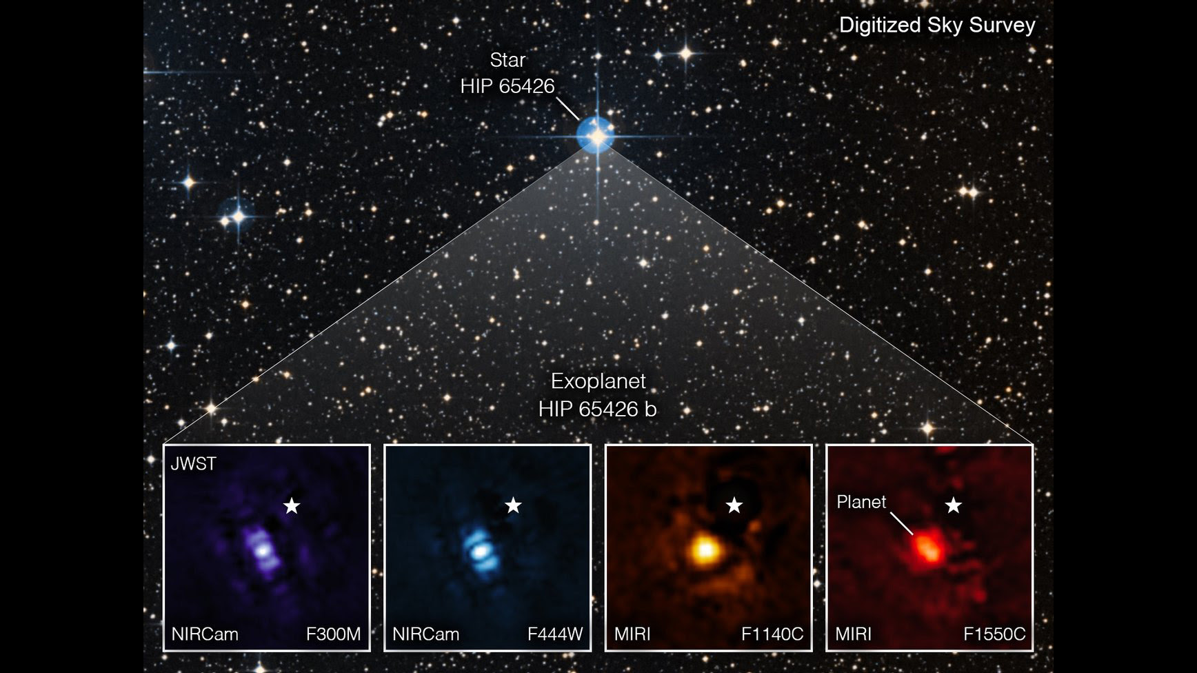
NASA’s Webb Takes Its First-Ever Direct Image of Distant World Sept. 2, 2022
Credit: NASA/ESA/CSA, A Carter (UCSC), the ERS 1386 team, and A. Pagan (STScI) One of the telescope’s instruments used to observe the planet is managed by the agency’s Jet Propulsion Laboratory. For the first time, astronomers have used NASA’s James Webb Space Telescope (JWST) to take a direct image of a planet outside our solar system. The exoplanet is a gas giant, meaning it has no rocky surface and is not habitable. The finding is detailed in NASA’s latest JWST blog entry. Two of Webb’s instruments observed the planet: the Near-Infrared Camera (NIRCam), and the Mid-Infrared Instrument (MIRI). NASA’s Jet Propulsion Laboratory in Southern California managed MIRI during its design, construction, and commissioning. Both instruments are equipped with coronagraphs, which are sets of tiny masks that block out starlight, enabling Webb to take direct images of certain exoplanets like this one, called HIP 65426 b. NASA’s Nancy Grace Roman Space Telescope, slated to launch later this decade, will use the even more advanced Coronagraph Instrument, which is also managed by JPL. News Media ContactCalla Cofield Jet Propulsion Laboratory, Pasadena, Calif. 626-808-2469 2022-131 For more information, please visit the following link: |
SOLAR SYSTEM
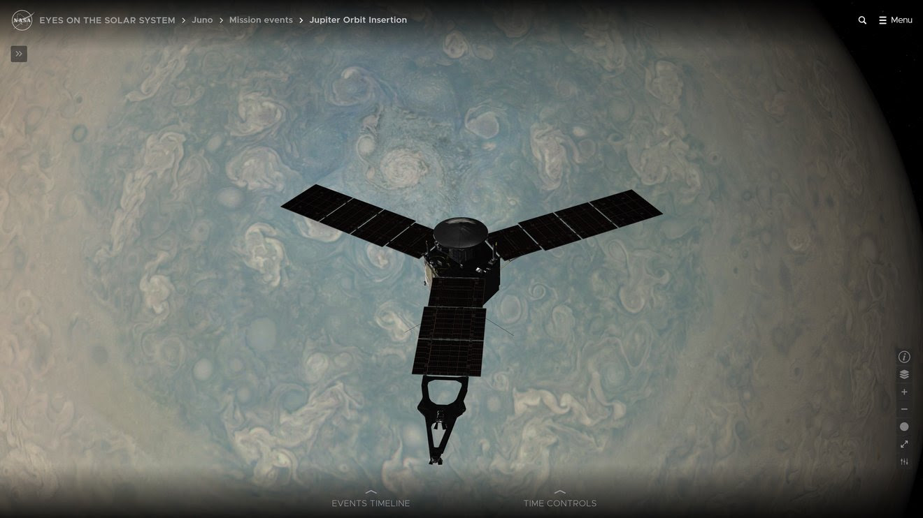
Explore the Solar System With NASA’s New-and-Improved 3D ‘Eyes’Sept. 2, 2022
Credit: NASA/JPL-Caltech The agency’s newly upgraded “Eyes on the Solar System” visualization tool includes Artemis I’s trajectory along with a host of other new features. NASA has revamped its “Eyes on the Solar System” 3D visualization tool, making interplanetary travel easier and more interactive than ever. More than two years in the making, the update delivers better controls, improved navigation, and a host of new opportunities to learn about our incredible corner of the cosmos – no spacesuit required. All you need is a device with an internet connection. Anyone with an internet-enabled device browser can explore the past, present, and future of the solar system in 3D with NASA’s interactive Eyes on the Solar System. Click anywhere on the image to get a closer look at a 3D rendering of NASA’s Cassini spacecraft flying by Saturn’s moon Enceladus in 2015. Learn the basics about dwarf planets or the finer points of gas giants, and ride alongside no fewer than 126 space missions past and present – including Perseverance during its harrowing entry, descent, and landing on the Red Planet. In fact, you can follow the paths of spacecraft and celestial bodies as far back as 1949 and as far into the future as 2049. While you’re at it, you can rotate objects, compare them side by side, and even modulate the perspective as well as the lighting. The visuals are striking. This latest version of “Eyes” also lets you scroll through rich interactive journeys, including Voyager’s Grand Tour of Jupiter, Saturn, Uranus, and Neptune. Watch a video tutorial to get started with ‘Eyes’ “The beauty of the new browser-based ‘Eyes on the Solar System’ is that it really invites exploration. You just need an internet connection, a device that has a web browser, and some curiosity,” said Jason Craig, the producer of the “Eyes” software at NASA’s Jet Propulsion Laboratory. News Media ContactMatthew Segal Jet Propulsion Laboratory, Pasadena, Calif. 818-354-8307 2022-130 For more information, please visit the following link: |
 VON KARMAN LECTURE
Ocean Worlds Life Surveyor
The Ocean Worlds Life Surveyor (OWLS) is the first life detection suite to explore a wide range of size scales, from single molecules to microscopic organisms, in a water sample.
This message was sent to ingpeaceproject@gmail.com from jplnewsroom@jpl.nasa.gov
NASA’s Jet Propulsion Laboratory
NASAJPL
4800 Oak Grove Dr
Pasadena, CA 91109
Leave a Reply